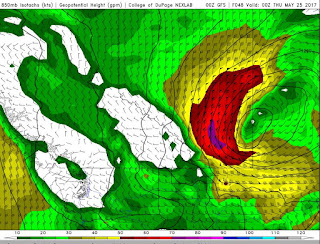
Looking at the latest GFS forecast model, an area of southern Alberta between Calgary and Medicine Hat will be the focus of a major wind storm on Wednesday. Peak sustained winds of 73 knots or 135km/hr are showing up as of 0z or 6pm local time. Tree and property damage begin to occur at 80km/hr which is the criteria to issue wind warnings by Environment Canada. This will go way above and beyond that so widespread power outages and major widespread damage will occur across most of the province. A special weather statement is already in place for the region and expect warnings to be issued very early so people can prepare. To put this into perspective, 135km/hr winds would make this a category 1 hurricane but since it is on land, it is considered an "Inland Cyclone".
In the graphic above, the purple area is 135km/hr, the red covering most of southern and central Alberta is 90 to 130km/hr. The yellow, which will affect nearly every area from Alberta to Manitoba is 55 to 90km/hr sustained winds. It is expected to last a strong two to three days and weaken by Friday. Keep in mind, this is just a model estimate and strengths and locations may shift. Wind gusts will be stronger, heavy rain and a drop in temperature is also expected. Check your local forecast and read all statements and warnings closely.
Today's Song via YouTube Music
Canadian Prairie Storms Pages
Tuesday, May 23, 2017
Thursday, April 27, 2017
Storm Season Gets Closer - May 6th?
Long term forecast models are showing a brief heat wave across Alberta and Saskatchewan, peaking May 6th with possible high temperatures of 26C. A cold front following off the mountains seems to suggest action within the supercell composite as well in west central Alberta. Certainly no guarantees on the timing, location, or intensity but something to note. Maybe just a glimmer of hope or maybe there will be some big storm action. By the looks of the map, the heat goes very far north into both Saskatchewan and Alberta. Remember, that is May 6th, a full 9 days out.
 |
| Image via http://weather.cod.edu/forecast/ |
Wednesday, July 20, 2016
Supercell Sunset and Lightning Strikes!
July 19, 2016
Regina, Saskatchewan
Between 8pm and 10pm I caught this incredible display of Saskatchewan's skies. A tornadic supercell to the north provided incredible sunset shots from near the RCMP Heritage Centre. Later, dry cg lightning strikes as seen from the south side of Wascana Lake.
Tuesday, July 19, 2016
Continuous Lightning 3am July 19, 2016
Just after the near zero visibility downpour, I caught some clips of continuous lightning flashes over downtown Regina after 3am. It was severe warned for about an hour but only produced the heavy rain for a few minutes, no hail or much wind. More of the same today and tonight!?
Monday, July 18, 2016
Southern Alberta! Be Prepared Tonight... #Supercells #Tornadoes #abstorm
The BIG storms are back today! Great heat energy combined with several days of seeding rains and a strong jet stream will fire off some huge storms in southern Alberta late in the day and run east overnight, maintaining power. Potential for very large hail and long track tornadoes exists but for the most part, it will be hot and sunny all day for most areas. We don't expect storms to "break the cap" until late in the day or maybe early evening but when they do, it will get vicious! Overnight, nocturnals will grow and cruise east into Saskatchewan setting up an even more powerful set up on Tuesday. Tuesday night into Wednesday the strongest of this system will show its teeth over eastern Saskatchewan and southern Manitoba. This is a system to take very seriously. Charge you devices and set your weather radio to ALERT. Here is the current risk map:


Subscribe to:
Posts (Atom)

