Tuesday, August 22, 2023

HOLD ON #SKSTORM Next Lightning Opportunity?: Midnight Wednesday, Cooler Today.. or read below for instant update

Forecast models are coming in colder this morning as rain has cooled things off significantly. As the sunshine begins to cook things up, it will be a matter of how fast the sunshine can boil up the atmospheric moisture. As of 8am Monday, we are looking at some organized thunderstorms, possible supercells entering the Regina City area by midnight Wednesday night. Extremely strong storms are possible with tornadoes, but for now those will stay south in North Dakota. .. HOLD ON...


Instant Update: The NAM Nest is coming back in hot, extreme storms with tornadoes now possible in southeast Saskatchewan or North Dakota. Watching this system close. I have Thursday off.


Sunday, August 20, 2023

Kelowna Fires / Hurricane Hillary / Tropical Storm Trudeau / Supercell Wednesday


Hoping for rain to put out dangerous wildfires in BC, especially Kelowna and it looks Hurricane Hillary has arrived to save the day, or maybe the week. By the time the first wave of rain hits Canada, we are calling it Tropical Storm Trudeau for saving the country. As a bonus, Tropical Storm Trudeau is expected to produce some supercell potential on Wednesday evening as the second wave crosses the land with much needed moisture.


Thursday, August 17, 2023

The Next Big System

Thursday, August 17th, 2023

Today's Thunderstorm Outlook from ECCC, showing a large risk area from the foothills through Edmonton to Lloydminster, Alberta. 


Up to 100km/hr wind gust and 4cm hail are possible. A tornado risk is low along the foothills from over the mountains in BC, later into the evening and overnight in west central Alberta.


Extreme heat is expected to push east into Saskatchewan and Manitoba on Friday. Depending on the timing, the short term forecast showing Regina hitting 97F/35C at 2pm while the high resolution mid-term forecast saying Brandon, Manitoba will get the big time heat wave.


Either way, there is a big system coming over the mountains which will affect everyone on the Canadian Prairies over the next few days. Expect a lot of wind, heat waves and storms to follow through the weekend until Sunday as it exits Manitoba. Good thing is, the rain should help knock down a few fires however with record ocean temperatures this summer, we should keep our A/C's up a few more weeks. Might stay hot with supercell thunderstorms much later this summer. 


Friday, August 11, 2023

Storm Front Timelapse Videos from August 10th, 2023

 Canon Photo Slideshow with video clips


Motorola G Power Timelapse


Sony FDR X3000 Action Camera Timelapse


Thursday, August 10, 2023

Storm Day Thursday, August 10th, 2023

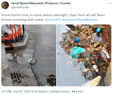
ECCC's Thunderstorm Outlook for Today:Storm drains had to be cleared out this morning after heavy rain and thunder overnight in Regina.


Smoke clears out at 4pm in ReginaForest Fires (FireSmoke.ca) 
Lightning starts at noon to 4pmLightning Density Forecast Map 
Risk of a tornado in southeast SaskatchewanCOD Next Generation Weather Lab (Forecast Models)
Wind gust profiles suggest a late system causing problems in southwest Saskatchewan up to 11pm
Extremely low visibility at midnight