Hoping for rain to put out dangerous wildfires in BC, especially Kelowna and it looks Hurricane Hillary has arrived to save the day, or maybe the week. By the time the first wave of rain hits Canada, we are calling it Tropical Storm Trudeau for saving the country. As a bonus, Tropical Storm Trudeau is expected to produce some supercell potential on Wednesday evening as the second wave crosses the land with much needed moisture.
Today's Song via YouTube Music
Canadian Prairie Storms Pages
Sunday, August 20, 2023
Thursday, August 17, 2023
The Next Big System
Thursday, August 17th, 2023
Today's Thunderstorm Outlook from ECCC, showing a large risk area from the foothills through Edmonton to Lloydminster, Alberta. |
Up to 100km/hr wind gust and 4cm hail are possible. A tornado risk is low along the foothills from over the mountains in BC, later into the evening and overnight in west central Alberta.
Extreme heat is expected to push east into Saskatchewan and Manitoba on Friday. Depending on the timing, the short term forecast showing Regina hitting 97F/35C at 2pm while the high resolution mid-term forecast saying Brandon, Manitoba will get the big time heat wave.
Either way, there is a big system coming over the mountains which will affect everyone on the Canadian Prairies over the next few days. Expect a lot of wind, heat waves and storms to follow through the weekend until Sunday as it exits Manitoba. Good thing is, the rain should help knock down a few fires however with record ocean temperatures this summer, we should keep our A/C's up a few more weeks. Might stay hot with supercell thunderstorms much later this summer.
Friday, August 11, 2023
Storm Front Timelapse Videos from August 10th, 2023
Canon Photo Slideshow with video clips
Motorola G Power Timelapse
Sony FDR X3000 Action Camera Timelapse
Thursday, August 10, 2023
Storm Day Thursday, August 10th, 2023
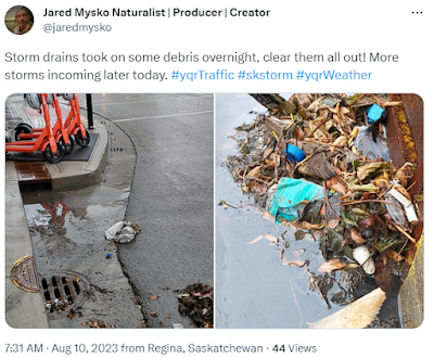
ECCC's Thunderstorm Outlook for Today: Storm drains had to be cleared out this morning after heavy rain and thunder overnight in Regina.
Smoke clears out at 4pm in ReginaForest Fires (FireSmoke.ca)
 Storm drains had to be cleared out this morning after heavy rain and thunder overnight in Regina.
Smoke clears out at 4pm in ReginaForest Fires (FireSmoke.ca)
Wednesday, August 09, 2023
Moderate Risk Day 2 Thursday, August 9th, 2023
Moderate Risk Day 2 Thursday, August 9th, 2023
Be READY for #skstorm tomorrow!
Technical discussion:
Two different scenarios featured by today's short and mid term forecast models. The hrrr shows more convection with storms over Regina, the NAM Nest is showing little to no convection for the city. Both models agree that the Estevan region will be in the DANGER ZONE from 4pm to at least 8pm. Regina might see more tornadic storms form later in the evening or overnight (7pm to 9pm and 1am). With experience of watching these patterns fold and unfold, our best guess is to put all of southern Saskatchewan on storm watch with southeastern areas ready to be on high alert in cast heat energy continues to over take the extreme humidity. Lack of ground water to the west will stir up winds, extreme humidity in the east may trigger tornadoes with this system.
Subscribe to:
Comments (Atom)


