Today's Song via YouTube Music
Canadian Prairie Storms Pages
Saturday, July 04, 2015
Friday, July 03, 2015
Massive Supercell Exploding Right Now Over Meadow Lake!
Many other cells now popping up further south towards Saskatoon and into south central Alberta. Here is a look at the current Echo Tops radar as of 2:10pm:
Closely monitor Environment Canada warnings if in the risk area and take cover if a storm approaches. These storms will be damaging and dangerous. Stay safe!
Updated risk area map:
Closely monitor Environment Canada warnings if in the risk area and take cover if a storm approaches. These storms will be damaging and dangerous. Stay safe!
Thursday, July 02, 2015
Big Storms On Friday And Saturday
As the forest fire smoke thickens once again over southern Saskatchewan, a major change in the weather patterns is about to occur. Today's northerly smoke filled winds will shift from the south on Friday, bringing heat and moisture to the prairies. Already like a simmering pot of soup, the air will be ripe for supercell thunderstorms to take over the weather picture for the next two days.
On Friday, central and southern areas of Alberta will be the focus of very high CAPE values (Convective Available Potential Energy), combined with a south east wind and a cold front diving in from the north the mix will be potent and result in some very strong thunderstorms with super cell structure, damaging winds and very large hail.
Here is the preliminary forecast map that may be upgraded or downgraded depending on the situation:
*Forecast models are not in agreement as the NAM is suggesting a major widespread event and the GFS is forecasting a much more subdued storm complex. Again, forest fire smoke could factor in and limit convection but we will have to keep on the safe side and calls em like we sees em...
Here is the map for Saturday, again things may not be as they seem to suggest:
As always, stay safe, be prepared and stay tuned to weather radios and Environment Canada watches, warnings and weather advisories.
Saturday, June 27, 2015
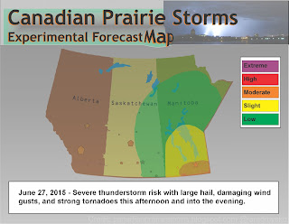
Tornado Warning In Manitoba [Moderate Risk Outlook Map]
Areas in south eastern Manitoba are in the moderate risk zone for severe weather this afternoon and into the evening. A tornado warning has just been issued:
2:23 PM CDT Saturday 27 June 2015
Tornado warning in effect for:
Tornado warning in effect for:
- R.M. of Dufferin including Carman Roseisle and Homewood
Updated or ended by 3:15 p.m. CDT.
At 2:23 p.m. CDT, Environment Canada meteorologists are tracking a severe thunderstorm that is possibly producing a tornado. Damaging winds, large hail and locally intense rainfall are also possible.
Doppler radar indicates a potential tornado near Roseisle moving 40km/h southeast.
At 2:23 p.m. CDT, Environment Canada meteorologists are tracking a severe thunderstorm that is possibly producing a tornado. Damaging winds, large hail and locally intense rainfall are also possible.
Doppler radar indicates a potential tornado near Roseisle moving 40km/h southeast.
Friday, June 26, 2015
Severe Thunderstorms With Flash Flooding [Today's Outlook Map]
There are some big storms popping up all over eastern and central Saskatchewan including Manitoba this afternoon. With extreme heat to the west, and high CAPE values, these slow moving, high topped storms will produce a lot of local rain which could result in flash flooding. Storms are expected to persist late into the evening where a chance of tornadoes exists around sundown.
Subscribe to:
Comments (Atom)


