On Friday, central and southern areas of Alberta will be the focus of very high CAPE values (Convective Available Potential Energy), combined with a south east wind and a cold front diving in from the north the mix will be potent and result in some very strong thunderstorms with super cell structure, damaging winds and very large hail.
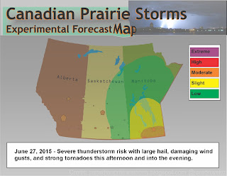
Here is the preliminary forecast map that may be upgraded or downgraded depending on the situation:
*Forecast models are not in agreement as the NAM is suggesting a major widespread event and the GFS is forecasting a much more subdued storm complex. Again, forest fire smoke could factor in and limit convection but we will have to keep on the safe side and calls em like we sees em...
Here is the map for Saturday, again things may not be as they seem to suggest:
As always, stay safe, be prepared and stay tuned to weather radios and Environment Canada watches, warnings and weather advisories.


