Tuesday, April 28, 2015

Storm Season / Heating Up / Safety Tip

As May approaches, tornado season in the states has been getting quite active with several major damaging storm events in April including this week's tornado fest in north central Texas and the massive wedge tornado just outside of Chicago a couple weeks ago. Video clips from that event are posted on our new Facebook page. Also, check out the "Weather Watch" international community of Google Plus. Another new innovation in the growth of storm casting which is already at an astounding 10'974 members! 

The "experimental forecast map" will be back in time for the first risk of severe summer weather which could be as soon as the middle of May. For now, it has been re-added to the side bar here. So keep checking back as this will continue to be the base of operations from whence all storm news comes from. There are a few new things being worked on to make this a more comprehensive and interactive site.  

Here is a little tip and a video from last night, thanks to +Reed Timmer for sharing: 

When people stop under a bridge during a tornado warning... good thing there was a storm chaser to shake some common sense into the fools blocking traffic. "You're gonna get us all killed!" They moved. Remember, never block traffic during a storm. Traffic jams can and have killed people simply because they stopped moving. Either go with the storm, away from the storm or stay in shelter. Never Stop Chasing! (and never be a sitting duck)


Video via Mike Scantlin +StormChaseTV 

Friday, March 13, 2015

Foggy Fog!

Its a nice foggy day here in Regina today, quite often the fog comes before the storm, or in this case the hot sunshine comes out in the afternoon and we have great warmth and calm winds. A very rare occurrence for the middle of flat prairie country. The forecast is for a bit of a heat wave but it will only continue the rapid drying and melting of remaining snow and ice in Regina, while just west of here, the snow is long gone and areas such as Calgary, Medicine Hat, Moose Jaw, Swift Current and the state of Montana will see upper teens and near 20 degrees Celsius temperatures! 

All of this is good news for those who are sick of winter but for storm chasers, SDS (Severe Weather Deprivation Syndrome) is setting in hard. So far 0 (zero) tornadoes reported in the month of March and we have seen the longest stretch of no watch advisories since 1986. The year has started out as the quietest storm season ever. It is all going to hit at once? That is the biggest worry as you get that feeling, "It is just wayyy too quiet" just before the big one hits. So, where are all the storms? Check out this map from Wunderground.com of the "World Map of Tropical Storms": 


4 tropical storms around Australia, where the big heat is still hiding.


Monday, March 09, 2015

Slow Start To Storm Season (Snow Cover Map/Waterfowl Migration)

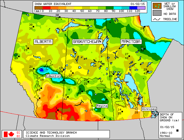
As deep freezing temperatures have vanished across much of the Canadian Prairies this week, spring begins its annual relief with thawing and melting well under way. By the looks of the snow cover maps, it is already very dry in the south west of Saskatchewan, including southern Alberta. There seems to be a dry line south of the Yellowhead Highway as cities such as Edmonton, Lloydminster, Saskatoon and Yorkton have the deepest moisture with the winter snow pack.

Map from Environment Canada
This means, the heat will be on early in the south west and without any significant rain or snow, it will be a very dry start to spring with more chance of dust storms this year. Hopefully, the drought does not spread to the rest of the farm belt. With very much normal snow packs along the Yellowhead, thunderstorms may have a difficult time getting too strong and tornadoes may be non-existent this summer in western Canada. All of this can change rapidly of course as spring showers often bring May flowers!

Here is a look at the current North American Snow Cover Map courtesy of NOAA:


These maps and more information can be found at Canadian Cryospheric Information Network


Also of note, the spring migration is just getting under way and you can see the progress of our natural seeders and fertilizers fly closer to your area via the Ducks Unlimited website.

Stay tuned to this blog for more updates on stormy weather this year!


Wednesday, August 20, 2014

August 19th, 2014 Lightning Storm


UPDATE: I was not the only one to see the green glow coming from the ground, several others tweeted about it and SaskPower had to deal with a major power outage to many area in and around Regina. It is believed to be a transformer explosion after a lightning strike just west of the city.

Good dry cg lightning show over Wascana Lake this evening, the last photo in this set is the green afterglow of a strike just as the shudder opened. I have never seen that before, weird.