Saturday, June 27, 2015

Tornado Warning In Manitoba [Moderate Risk Outlook Map]

Areas in south eastern Manitoba are in the moderate risk zone for severe weather this afternoon and into the evening. A tornado warning has just been issued:

2:23 PM CDT Saturday 27 June 2015
Tornado warning in effect for:
  • R.M. of Dufferin including Carman Roseisle and Homewood
Updated or ended by 3:15 p.m. CDT.

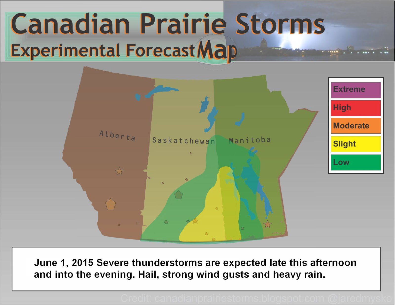
At 2:23 p.m. CDT, Environment Canada meteorologists are tracking a severe thunderstorm that is possibly producing a tornado. Damaging winds, large hail and locally intense rainfall are also possible.

Doppler radar indicates a potential tornado near Roseisle moving 40km/h southeast.


Friday, June 26, 2015

Severe Thunderstorms With Flash Flooding [Today's Outlook Map]

There are some big storms popping up all over eastern and central Saskatchewan including Manitoba this afternoon. With extreme heat to the west, and high CAPE values, these slow moving, high topped storms will produce a lot of local rain which could result in flash flooding. Storms are expected to persist late into the evening where a chance of tornadoes exists around sundown.


Wednesday, June 24, 2015

Weak Tornadic Storms Today, Bigger Ones Friday...

Tornado Warnings have been issued in southern Manitoba this afternoon with confirmation of at least one touchdown.


The storms today are are very slow moving, mostly rain event type with some possible spin ups of weak tornadoes. There will be no map today, keeping with the consistent model forecasts of scattered non-severe thunderstorms. If any damage occurs from these cells, it will be a possible tipped lawn chair and a lot of rain. Flash flooding should be the main concern today.

Friday on the other hand, looks to be quite active for stronger type supercell thunderstorms that can cause widespread damage. Here is a look at the difference between the NAM forecast model for 9pm this evening and 9pm Friday evening. This is the forecast "supercell composite":

Wednesday 9pm Supercell Composite

Friday 9pm Supercell Composite

Saturday, June 20, 2015

Storms Moving Into Manitoba Today

After a very active day yesterday, systems are pushing east into Manitoba. Today's storms are not expected to be tornadic or have very organized supercellularities thus, the slight risk is only for gusty winds, small hail, intense lighting and heavy rains. After today, if anything severe, the rest of next week is forecast to have general to marginal thunder showers and nothing very severe until closer to Canada Day. July 1st to 3rd is looking like the next big system at the height of storm season on the Canadian Prairies. Plan accordingly and as always, be prepared and stay safe!


Friday, June 19, 2015

Storm Chasing Action via Mountain Bike!


Regina, Saskatchewan

June 19, 2015

5:50pm to 6:30pm


Began to see nice structure by the stadium construction site. At Dewdey and Lewvan Drive, I decided I had gone far enough as a rain and hail shaft began to appear! Initially, radar had indicated that it was moving slowly south east (15km/hr), making for an easy chase by bike. But suddenly, the line of cells began to wrap around and the south end rapidly flew across the city (after analysis at home, calculated it clocked up to 60km/hr and became tornado warned just 70km east of the city). Rode the storm home in 20 minutes via mountain bike! Some footage shot in action as i strapped the camera to my back and booked it towards safety! Now that's storm chasing! Pea size hail and a brief heavy downpour as I got home. Barely got wet.

Storm Chasing By Mountain Bike Today - Photos - 7pm Tornado Warning

Began to see nice structure by the stadium construction site. At Dewdey and Lewvan Drive, I decided I had gone far enough. Rode the storm home in 20 minutes via mountain bike! Now thats storm chasing! Pea size hail and downpour as I got home. Barely got wet.

[scroll down for warning] 


...and now:
7:00 PM CST Friday 19 June 2015
Tornado warning in effect for:
  • R.M. of Francis including Vibank Sedley and Odessa
  • R.M. of Indian Head including Indian Head and Sintaluta
  • R.M. of Montmartre including Assiniboine Res.
Updated or ended by 7:59 p.m. CST.

At 7:00 p.m. CST, Environment Canada meteorologists are tracking a severe thunderstorm that is possibly producing a tornado. Damaging winds, large hail and locally intense rainfall are also possible.

Weather radar indicates a potential tornado approximately 15 km south-southwest of Indian Head. This storm is travelling to the southeast at approximately 50 km/h. The storm will track southeastwards to the north of Highway 48.

Severe Weather Outlook Today

Strong storms are expected to fire up early today before noon across much of southern Saskatchewan. This includes a low probability of tornadoes, 2% in the Regina area and 5% along the international border. There is some dispute among forecast models with the NAM calling for a more widespread event from the Yellowhead Highway south and into Manitoba while other models are saying storms will be confined to south of the Number One Highway in Saskatchewan. The undisputed biggest risk remains further south into the Dakotas where SPC is calling for an "enhanced" risk with a large area projected for tornadic action.

The main focus here will be in southern Saskatchewan as many areas could be hearing thunder and seeing large dumps of rain. Possible flash flooding locally and small to moderate sized hail. Damaging winds are not expected but can not be ruled out in stronger cells with the odd weak tornado. If anything, stay up to date with current advisories and watches, keep weather radios and cell phones charged, and always be prepared!


Thursday, June 18, 2015

Three Days Of Severe Thunderstorms

There is expected to be some severe weather along southern areas of the Canadian Prairies to end the week, starting this afternoon in southern Alberta. The main feature of these storms will be large hail and damaging winds. Much stronger storms will remain south of the international border. Storms will move east Friday and Saturday into south eastern Saskatchewan and Manitoba.


Sunday, June 14, 2015

Quiet Pattern For Prairies, Hurricane Forming In The Gulf

Long term forecast models are suggesting no significant storm systems for at least the next 2 weeks. Meanwhile tropical storm forecasters are giving an 80% chance the low pressure system in the Gulf of Mexico will turn into a tropical storm. This quiet pattern is normal on the prairies during September at the height of tropical storm season. So while we wait for storms to come back to the prairies in July, there very well could be the makings of a major hurricane event much further south.


Saturday, June 13, 2015

Today's Outlook Map: Manitoba #mbstorm

Strong thunderstorms exit the prairies tonight as this system pushes across Manitoba. A large complex of storms in north central parts of the province will feed a long line towards the south western border and this thin line of storms will have severe cells that track all the way east into the evening. Large hail, damaging winds gusts and heavy rain will be the main features.


Friday, June 12, 2015

Active Day Ahead: #SkStorm #MbStorm [Risk Map]

Areas along the Saskatchewan/Manitoba border are seeing remnants of last nights nocturnals this morning and this system of rain is expected to feed strong thunderstorms further south west into southern Saskatchewan. Strong daytime heating in the south combined with high humidities and a vigorous "Gulf Stream" (Gulf of Mexico southerly winds) along the SK/MAN border will kick off very strong storms in the Yorkton region of south east Saskatchewan. Later this afternoon, storm cells will spread all the way west into the Lethbridge area of southern Alberta with a risk of becoming severe. Heavy rains including a risk of flash flooding, large hail and strong winds are to be expected in severe level cells. If in these areas of risk, remember to check Environment Canada for updated alerts and keep your weather radio close by. Stay safe!


Thursday, June 11, 2015

Supercells in Alberta and Saskatchewan [Updated Risk Map]

Supercell thunderstorms have emerged over parts of south west Saskatchewan and southern Alberta. Earlier, tornado watches and severe thunderstorm warnings caused a delay in the Women's World Cup soccer match between Canada and New Zealand in Edmonton. That storm has now moved east of the city and the game has resumed. Watches and warnings are now active and several areas of south west Saskatchewan and eastern Alberta. Check Environment Canada for current alerts.

Here is a snap shot of the Echo Tops reaching near 50k feet as of 7:30pm SST:


Updated Severe Weather Outlook Map as of 8pm:


Two Days Of Strong Storms [Current Map With Details]

The PSPC (Prairie and Arctic Storm Prediction Centre) is pulling no punches with its forecast this morning, mentioning "long lived severe thunderstorms", "golf ball size hail" and "90km/hr damaging wind gusts." Edmonton to Lloydminster will be the main areas to watch as storms become severe later this afternoon and into the evening. Storms are expected to reach the Saskatchewan border by sundown and weaken but not die off completely. Nocturnal thunderstorms could continue through the night and feed a larger outbreak across much of the northern grain belt and into south east Saskatchewan and western Manitoba on Friday. We will update this story with another forecast map later this afternoon or early evening depending on the timing and strength of this system.


Saturday, June 06, 2015

Video Of Lightning Storm - May 31st [with music and EPIC ending]

Sped up 4x until the EPIC ending with super slow motion 0.25x

Father and Son Storm Chasing Team
"The Storm Marshall's"
Video footage by William Mysko
Editing by Jared Mysko
Musical Credit: Flight Of The Bumblebee - Rimsky-Korsakov


View Of The Storm Friday Evening

Here is the view of the storm base from downtown Regina as it passed to our north.


Today's Outlook Map

There is a chance of severe thunderstorms today in south-eastern Saskatchewan and southern Manitoba. These storms are not expected to be too strong with the main features being heavy rain and small hail. General thunderstorm cells are possible in a wide area of the prairies but will not become severe.


Friday, June 05, 2015

Severe Thunderstorm Warnings Issued [Updated Risk Map]

Storms continue to move across southern Saskatchewan this evening, some strong enough to have watches and warnings issued. For the most part, these storms will only bring brief downpours, small hail and strong wind gusts. Check your weather radio or Environment Canada's current warnings page for details. As of 6:39pm, a severe thunderstorm warning was issued for the city of Moose Jaw and a Severe Thunderstorm Watch was issued for the city of Regina (which set off my new weather radio in the middle of watching the movie Jurassic Park, REALLY LOUD LOL) 

...and as I write this, the latest radar scans show the line of storms coming off Diefenbaker Lake have rapidly dissipated to near extinction.... back to the movie, looks like the storms are all gone...


Today Severe Thunderstorm Risk Map

June 5, 2015

Severe thunderstorms this afternoon including hail heavy rain, lightning and strong wind gusts. Watches have been issued including an advisory for funnel clouds and weak landspout tornadoes.


Tuesday, June 02, 2015

Saskatchewan Rivals The Driest Places On Earth This Spring!

At first, I knew it was a dry spring and when I read the latest numbers tweeted by Tiffany at Global News Regina, I was not surprised. Only 9.6mm fell in the city of Regina over the month of May.
Then today, I read a tweet from Peter at Global News in Saskatoon. Only 0.4mm fell in the city of Saskatoon during the month of May. I had to ask if this was a mistake and he meant centimeters.

Nope! Here is the provided official climate data from Environment Canada:

Environment Canada Climate Data

After doing some checking of the driest places on Earth, I found the the Sahara Desert gets approximately 7mm of rain during the month of May. Among the listed driest places on Earth, Waidi Halfa, Sudan gets 2.4mm of rain annually while parts of Egypt, Libya, Chile and the Antarctic get even less to none!

The current long term forecast shows no major change to this dry trend in Saskatchewan. In fact, nothing of significance at all for at least 2 more weeks. People need to take this very seriously in Regina where the city is pleading with residents to cut back on water use. Sadly, with so many new and younger residents, they have no idea what a major drought can do here. Its been a long time since the last major drought but both the "Dirty 30s" and droughts in 1988 and 2000-03 (Encyclopedia of Saskatchewan:Drought) had devastating effects on the economy and living conditions, not only here but in a massive ripple down effect since Saskatchewan is still considered the "breadbasket of North America".


Monday, June 01, 2015

Tonight's Severe Weather Outlook Map

June 1st, 2015

Storms will continue moving east overnight along the Manitoba/North Dakota border. Hail, strong wind gusts and heavy rain are the main risks associated with these storms. Another larger system in Montana may touch the extreme southern border of Saskatchewan late tonight. On Tuesday, storms are expected to keep south of the international border with a possible risk of strong tornadoes in the Dakotas. Much needed rain for the city of Regina has once again missed us and water rationing by residents and businesses begins to ramp up as severe drought threatens the area.


Today's Severe Weather Outlook Map

June 1, 2015

Severe thunderstorms can be expected later today in south east Saskatchewan and along the Manitoba border into the evening. Hail, strong wind gust and heavy rain will be the main threats.


Sunday, May 31, 2015

New Forecast Map: Version 2015

Here is our first map of the season with storm season right on track as we enter the month of June. Storms may persist overnight throughout areas of southern and central Saskatchewan, bringing a risk of small hail, gusty winds and heavy downpours. The risk moves east and south for the day tomorrow as this system begins to pick up steam and build toward the Dakotas, Monday and Tuesday.


*This latest version of the Experimental Forecast Map was re-built using the original format from 2012 by CorelDraw and can now be updated using the new "Fire Alpaca" software.
 (its always fun to try out new programs!)

Tuesday, May 26, 2015

Drought Continues! North Dakota Possibilities June 2nd?

The first real chance for severe thunderstorms on the northern plains looks to be June 2nd to 3rd however, current GFS (Global Forecast System) model suggests things will stay south of the US border. It shows that central North Dakota 'could' have severe weather including supercells that day with systems moving towards southern Manitoba on the 3rd. Earlier model runs showed storms possible in southern Saskatchewan on June 2nd as well, so things can easily shift. Personally, I have very little confidence our extremely dry pattern will change any time soon. A strong system in North Dakota could possibly feed some much needed moisture for future development later on around the 7th of June. Right now, looking at humidity and dew point levels, any convection is getting quickly sucked up by near drought conditions at the surface. 30% humidity does not equal thunderstorms of any kind in my books. Dry lightning and low precipitation, high based thunder clouds do not excite me. There is a better chance of severe drought and dust storms than anything else this year, maybe a grasshopper infestation?!

Tuesday, April 28, 2015

Storm Season / Heating Up / Safety Tip

As May approaches, tornado season in the states has been getting quite active with several major damaging storm events in April including this week's tornado fest in north central Texas and the massive wedge tornado just outside of Chicago a couple weeks ago. Video clips from that event are posted on our new Facebook page. Also, check out the "Weather Watch" international community of Google Plus. Another new innovation in the growth of storm casting which is already at an astounding 10'974 members! 

The "experimental forecast map" will be back in time for the first risk of severe summer weather which could be as soon as the middle of May. For now, it has been re-added to the side bar here. So keep checking back as this will continue to be the base of operations from whence all storm news comes from. There are a few new things being worked on to make this a more comprehensive and interactive site.  

Here is a little tip and a video from last night, thanks to +Reed Timmer for sharing: 

When people stop under a bridge during a tornado warning... good thing there was a storm chaser to shake some common sense into the fools blocking traffic. "You're gonna get us all killed!" They moved. Remember, never block traffic during a storm. Traffic jams can and have killed people simply because they stopped moving. Either go with the storm, away from the storm or stay in shelter. Never Stop Chasing! (and never be a sitting duck)


Video via Mike Scantlin +StormChaseTV 

Friday, March 13, 2015

Foggy Fog!

Its a nice foggy day here in Regina today, quite often the fog comes before the storm, or in this case the hot sunshine comes out in the afternoon and we have great warmth and calm winds. A very rare occurrence for the middle of flat prairie country. The forecast is for a bit of a heat wave but it will only continue the rapid drying and melting of remaining snow and ice in Regina, while just west of here, the snow is long gone and areas such as Calgary, Medicine Hat, Moose Jaw, Swift Current and the state of Montana will see upper teens and near 20 degrees Celsius temperatures! 

All of this is good news for those who are sick of winter but for storm chasers, SDS (Severe Weather Deprivation Syndrome) is setting in hard. So far 0 (zero) tornadoes reported in the month of March and we have seen the longest stretch of no watch advisories since 1986. The year has started out as the quietest storm season ever. It is all going to hit at once? That is the biggest worry as you get that feeling, "It is just wayyy too quiet" just before the big one hits. So, where are all the storms? Check out this map from Wunderground.com of the "World Map of Tropical Storms": 


4 tropical storms around Australia, where the big heat is still hiding.


Monday, March 09, 2015

Slow Start To Storm Season (Snow Cover Map/Waterfowl Migration)

As deep freezing temperatures have vanished across much of the Canadian Prairies this week, spring begins its annual relief with thawing and melting well under way. By the looks of the snow cover maps, it is already very dry in the south west of Saskatchewan, including southern Alberta. There seems to be a dry line south of the Yellowhead Highway as cities such as Edmonton, Lloydminster, Saskatoon and Yorkton have the deepest moisture with the winter snow pack.

Map from Environment Canada
This means, the heat will be on early in the south west and without any significant rain or snow, it will be a very dry start to spring with more chance of dust storms this year. Hopefully, the drought does not spread to the rest of the farm belt. With very much normal snow packs along the Yellowhead, thunderstorms may have a difficult time getting too strong and tornadoes may be non-existent this summer in western Canada. All of this can change rapidly of course as spring showers often bring May flowers!

Here is a look at the current North American Snow Cover Map courtesy of NOAA:


These maps and more information can be found at Canadian Cryospheric Information Network


Also of note, the spring migration is just getting under way and you can see the progress of our natural seeders and fertilizers fly closer to your area via the Ducks Unlimited website.

Stay tuned to this blog for more updates on stormy weather this year!


Wednesday, August 20, 2014

August 19th, 2014 Lightning Storm


UPDATE: I was not the only one to see the green glow coming from the ground, several others tweeted about it and SaskPower had to deal with a major power outage to many area in and around Regina. It is believed to be a transformer explosion after a lightning strike just west of the city.

Good dry cg lightning show over Wascana Lake this evening, the last photo in this set is the green afterglow of a strike just as the shudder opened. I have never seen that before, weird.

Thursday, May 29, 2014

Lightning Over The Lake

It took nearly 200 photos, a lot of patience waiting for the storm and convincing myself that is wasn't done yet as the wind stopped and lightning flashes became very infrequent but here is the results:

Wascana Lake 12:39am

Wascana Lake 12:40am

Wednesday, May 28, 2014

LIVE Regina, Saskatchewan SKYCAM #SKSTORM

LIVE Regina, Saskatchewan SKYCAM #SKSTORM

https://www.youtube.com/watch?v=cqdd3kFkhUE

(hopefully this works, otherwise I will be back near midnight to fix..)

Tuesday, May 27, 2014

Severe Weather Outlook Map - Wednesday, May 2014

Valid 5pm Wednesday, May 28, 2014

Issued at 10:30pm Tuesday, May 27, 2014

(this map is experimental and may be updated as needed)


CMYK (for print)

RGB (for digital)

North Dakota Perfect Tornado Yesterday

The footage of this tornado is amazing, lucky no one was killed but ABC news reports 9 injured as this tornado destroyed an oil camp in North Dakota May 26, 2014

Language and stupidity warning!

Dangerous Situation! #WednesdayNight

Extreme Southern Saskatchewan, including Assiniboine, Weyburn and Estevan Regions and All of Eastern Montana! 

PLEASE BE PREPARED FOR STORMS ON WEDNESDAY

Severe weather models are pointing to a major system exploding with tornadic supercells over western Montana Wednesday afternoon and moving into extreme southern Saskatchewan into the evening. These damaging storms will move into southern Manitoba and south eastern Saskatchewan on Thursday, making this a 2 day severe weather event. If in these areas, make plans now for strong storms and possible tornadoes, power outages, flash flooding, large hail and damaging winds.  

Here are some of the images of the latest forecast models, GFS and NAM, both seeming to suggest a lot of mixing with tons of wind shear, maximum ehi index and supercell composites, rain/precip just to the north. City of Regina could see flash flooding overnight with power outages all night Wednesday into Thursday.

GFS wind 850 9pm

NAM ehi index 9pm

GFS precip 9pm

NAM precip midnight

GFS supercell 9pm

NAM supercell 9pm

Stay safe, stay tuned and be prepared! 

More updates as they come in...

Monday, April 28, 2014

Storm Season Has Started In The States

A massive storm system has unleashed terrible fury in the latest start ever to tornado season in the states. Four days of severe weather had been forecast to hit southern tornado alley states starting on Saturday but after a blue sky bust that day, storms began to explode first thing Sunday morning and continue to pound many states into Monday evening with no slow down in sight. Moderate Risk was raised to High Risk early Sunday with 32 tornadoes reported on the Storm Prediction Center page. One was said to have been a multi-vortex with a destructive path of 80 or more miles long in Alabama with many injured and some killed.

Image grab from the animated wind map: (Apr27,2014-345pm) :


NASA Satellite Images:


...and from today:


At the latest count as of 8:21pm SST, the tornado count for today stands at 33 with another Moderate Risk issued for tomorrow for states just east of today's storms. Follow twitter feeds on the right of this page or check our live chaser links below for the latest.

Stay Safe!!!!


Wednesday, March 05, 2014

More Heavy Snow Tonight For Regina!

Having vastly under estimated snowfall totals this morning, it was with great enthusiasm, the snow shovel and scraper was taken to clear paths and walkways in anticipation of the big dump tonight. Between 6 and 8 cm of snow fell in a very short time early this morning and the storm system seemed to energize over the city of Regina wreaking havoc on city roads and side streets. Heavy snowfall warnings have just been issued for areas of south east Alberta as the next wave approaches. Forecast is saying 5 to 10 more cm of snow tonight with yet another 2 to 4 cm on Thursday. All this snow will be followed by much needed above normal temperatures for the first time in many weeks.

So get your shovels out and enjoy the warm temperatures, winter's grip is finally falling apart and we all badly need the snow shoveling therapy after the coldest winter in history has kept us huddled inside and attempted to challenge our pride!

We will succeed and the snow will melt, lets help it out straight to the curb and into the gutter where it belongs!

Heavy Snow Hits Regina (5am to 8am photos/video)

8am


As of 8am we have had about 2 cm of snow in the past hour here in Regina and 10 to 15cm more is expected in the next 24hrs. By the looks of the sky cam, the ledge has risen 6 to 8cm overnight.


7am


5am


Wednesday, February 12, 2014

PRAIRIE SNOW STORM TODAY [Skycam and ground footage videos]


Rush hour chaos as the storm began to peak in intesity at 4:30pm. This footage was shot at Victoria and Broad Street in Regina, Saskatchewan. A winter storm warning is in effect with up to 15cm of snow expected overnight with wind gusts near 70km/hr. Visibility is only a few meters within the city and travel on highways in not at all recommended with zero visibility and quickly accumulating snow drifts. Highways may in fact be shut down after sunset across southern Saskatchewan. Please check the highway hotline for the latest conditions.

http://www.highways.gov.sk.ca/road-conditions/

UPDATE: Highway #1 is NOW CLOSED between Regina and Moose Jaw as of 5pm
(Reading reports of a crash involving a semi, ambulance and other vehicles on highway #1, stay tuned to the #skstorm feed in the right hand column for up to the second reports)

STAY SAFE

LIVE SKYCAM:

Wednesday, January 15, 2014

Damaging Wind Storm Sweeps The Prairies


Winds gusted near 100km/hr today in Regina breaking off tree branches and littering the snow with pine needles and twigs. One large branch was captured as it broke off in Wascana Park which made me jump a little and freaked a squirrel right out! Some reported gusts higher at the airport and downtown but no major damage reports as yet for Regina, unlike Saskatoon which held the peak gust report with Prince Albert at 107km/hr. Semi-tractor trailer units were toppled on the highways, a window was blown out of an office building, a cell phone tower fell over and major large trees were bent or broken.


Here is a collection of tweets from the wind storm today:


Friday, January 10, 2014

Thick Fog Downtown Regina, Saskatchewan at 4pm


With a major warm up this week, today steady at 8C and 93% humidity, thick fog has made highway driving very dangerous as frost accumulated on the roads and visibility is reduced. This is expected to change to heavy snow for some areas on Saturday as a big system crosses the Rocky Mountains. Snowfall warnings and advisories are now in place for much of southern BC. Saturday's latest forecast calls for temperatures to rise near 0C with light snow and gusty winds. This may be upgraded depending on the track of the storm. Stay Safe!

Tuesday, January 07, 2014

Iqaluit Super Blizzard Update

With a reported 141km/hr wind gust and sustained winds over 100km/hr for the last 6 hours, Environment Canada has detailed a warning for the areas affected in Canada's north eastern territory of Nunavut. They are saying the center of the storm is expected to go over the capital region of Iqaluit tonight and winds should ease overnight but then re-fire in full intensity in the morning. Power has been going on and off in the region with roofs and building being torn apart. Many residents using twitter to update the world on this incredible weather phenomenon. Not the first time they get Super Blizzards but many saying it is the most powerful in many years.

CBC As It Happens posted this video from the scene this afternoon:


You can view tweets as they come in from the search term "Iqaluit" here:

Read the current warning from Environment Canada here

Power Out In Iqaluit, Nunavut - 135km/hr Blizzard Winds Reported!

Pray for those hunkered down in Iqaluit, NU the power has gone out and they are in the middle of a super blizzard with 140km wind gusts.The forecast says its only just started in Iqaluit and these winds (120 to 140 km/hr) will last for 2 days!

Here is someone I found tweeting from the storm:


Already damage being reported via Facebook:
Next doors shed flown away! Stay safe.


Friday, January 03, 2014

Snow Storm Today!

Heavy blowing snow today across southern Saskatchewan. Windchill warnings for the north, winter storm warnings for the south. The snow has eased up somewhat in Regina but winds have really picked up, now gusting over 50km/hr. Super cold temperatures are to follow this weekend, windchills may be as low as -55C in northern Saskatchewan. Stay tuned! More footage being uploaded now...