

Play by Play Commentary on Local and International Weather Events
Documentation and Relay Alerts of Severe Weather Events from Regina, Saskatchewan.
The Source Since 2002
Sunday, May 26, 2013
Today's Risk Map - 2pm Update
Severe thunderstorm watches have been issued for cities of Regina and Saskatoon and areas of south central Saskatchewan. Main threat is damaging wind gusts and large hail. These storms have potential to be very powerful.

Saturday, May 25, 2013
Today's Severe Thunderstorm Outlook Map
Tonight and into Sunday, areas of southern Saskatchewan will see severe weather in the form of thunderstorms with a possibility of large hail, intense lightning and brief heavy rain.


Wednesday, May 15, 2013
Spring and Summer Weather Hazards
Awesome 30-yr tornado database map included here with Spring and Summer Weather Hazards and safety information from David Sills - Environment Canada
 |
| Click the map for Environment Canada info source |
Monday, May 13, 2013
Slight Chance Of Severe Thunderstorms Tonight (New Map)

Minimal at best but there does appear to be a slight risk of severe weather in south west parts of the Canadian Prairies tonight. Severe thunderstorm watches are now active further south in Montana and Idaho and this system is expected to make its way into Canada over night. Wind warnings are up for Cypress Hills areas with expected 100km/hr wind gusts possible tonight and into Tuesday morning. Heavy rains are possible as storms track across southern Alberta and Saskatchewan. Most of southern Saskatchewan are enjoying high temperatures of 29 to 30 Celsius from Moose Jaw to Regina, Weyburn and Estevan.
If anything, its a good chance to dust off the map for the first time in 2013!
Wednesday, May 08, 2013
End Of The Flood
Confirmation this evening by Regina city workers monitoring Wascana Creek
the #SaskFlood has peaked at this location http://youtu.be/TUX-pu0Cj3E

the #SaskFlood has peaked at this location http://youtu.be/TUX-pu0Cj3E
Sunday, May 05, 2013
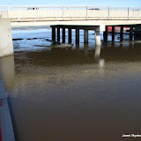
Flood Watch 2013-05-05 (Geo-Tagged)

Click the photo above to see the map and all 63 geo-tagged photos from around the Regina Wascana flood zone. Below are some of the most significant shots of the day. Due to the early opening of the flood gates, areas downstream are much higher now compared to the lake relative to 2011 flood levels.
Video will be processed overnight and another trip around the lake before sundown will give a good indication of how fast things are developing with temperatures now over 20C.


Flood Watch - Sunday, May 5, 2013 - 1pm
Water is starting to jump onto the path in some areas of Wascana Lake today.

I will make a full post when I get back, heading to the creek now to shoot footage. Reporting from the Saskatchewan Legislature ,
Jared Mysko

I will make a full post when I get back, heading to the creek now to shoot footage. Reporting from the Saskatchewan Legislature ,
Jared Mysko
Saturday, May 04, 2013
More Geo-Tagged Photos From Today / Park Flooding
The rising waters on Wascana Creek are starting to enter the park on the west side of Albert Street in Regina, Saskatchewan today.
Flood Watch 2013-05-04 (Geo-Tagged)

Click the photo to see the album and map.
16 photos with geographical location id
All content by Jared Mysko
Flood Watch 2013-05-04 (Geo-Tagged)
Click the photo to see the album and map.
16 photos with geographical location id
All content by Jared Mysko
Friday, May 03, 2013
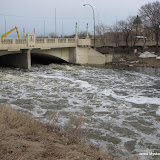
INCREDIBLE TIDAL WAVE OF ICE ON THE SASKATCHEWAN
A rare sight to behold, a surge of rising water on the Saskatchewan River crushes through an ice jam in north east Saskatchewan on Wednesday.
Ice Surge - Saskatchewan Water Security Agency
Ice Surge - Saskatchewan Water Security Agency
Wascana Flooding Situation - May 2, 2013 #Regina #Saskatchewan
NEW Video from yesterday:
Playlist of all footage so far from around Wascana Lake as the flooding situation develops:
Playlist of all footage so far from around Wascana Lake as the flooding situation develops:
Flood Watch 2013-05-02 (Geo-Tagged)
Click the above photo to see the location map of 16 photos of the flood situation around Wascana Lake and Creek in Regina, Saskatchewan as of Thursday, May 2, 2013
Flood Watch 2013-04-29 (Geo-Tagged)
Click the above photo to see the location map of 5 photos of the flood situation around Wascana Lake and Creek in Regina, Saskatchewan as of Monday, April 29, 2013
Flood Watch 2013-04-28 (Geo-Tagged)

Click the above photo to see the location map of 11 photos of the flood situation around Wascana Lake and Creek in Regina, Saskatchewan as of Sunday, April 28, 2013
Flood Watch 2013-04-27 (Geo-Tagged)

Click the above photo to see the location map of 11 photos of the flood situation around Wascana Lake and Creek in Regina, Saskatchewan as of Saturday, April 27, 2013
Flood Watch 2013-04-26 (Geo-Tagged)

Click the above photo to see the location map of 6 photos of the flood situation around Wascana Lake and Creek in Regina, Saskatchewan as of Friday, April 26, 2013
Subscribe to:
Posts (Atom)