Smoke briefly cleared out a storm cloud view, however strong thunderstorms were hidden behind the smoke shield for the most part as I filmed from Wascana Lake yesterday. Radar indicated storms just west of the city (Pense) but they kept rolling by northbound and wildfire smoke wrapped it up for me. September 9th continues to show potential. It not over yet!

Play by Play Commentary on Local and International Weather Events
Documentation and Relay Alerts of Severe Weather Events from Regina, Saskatchewan.
The Source Since 2002
Thursday, August 31, 2023
Calgary Skyline Lightning This Morning via Kyle Brittain on X
Wow some incredible lightning strikes, here is one of the amazing photos found on X Twitter:
Who is all awake in Calgary now? #yyc #abstorm pic.twitter.com/PxNeVyCPSe
— Kyle Brittain (@BadWeatherKyle) August 31, 2023
Wednesday, August 30, 2023
Tuesday, August 29, 2023
Moderate Risk #skstorm Supercells on Wednesday
The latest high resolution forecast model is showing a line of strong thunderstorms across southeast Saskatchewan between 5pm and 9pm, moving northeast from there overnight into Manitoba for Thursday's risk. Up to 2 cm hail and flash flooding are the main risks. High winds and tornado risk are very low. Supercell structure might be good. Note: tornado risk increases overnight into Thursday for Manitoba. Several waves possible.


Potential 220 km/hr Landfall for Hurricane Idalia
Check out the potential maximum wind gust via the NAM Nest for #Hurricane #Idalia from 119 knots at land fall, 80 knots well inland through Tallahassee, Florida. #FLwx
— ⚡️StormRangerBike🤠🚲 (@StormRangerBike) August 29, 2023
119 knots=220km/hr=137mph
80 knots=148km/hr=92mph
Lots of potential to damage structures at those rates. pic.twitter.com/YRuy4n6zVG

Danger Area in northern Florida Wednesday morning
Monday, August 28, 2023
Strong Thunderstorm / Weak Tornado Wednesday
Spotted a tornado in the first run of the NAM Nest 18z which shows a system developing over the city of Regina between 7pm and 9pm with 0.74 inches/1.9cm of rain, potential for a weak tornado and the supercell index climbed well above what the GFS was saying last night. Looks very localized, most of southeast Saskatchewan will get showers and lightning at most. Keep in mind the smoke could tear this whole idea apart, wildfire / forest fire smoke continues to be very bad in the far north. Add a strong full moon cycle as well into the mix and it will get interesting for sure, storm season isn't over.


Today's Song: Bad Moon Rising
Check TimeAndDate.com for moon phases and SpaceWeather.com for Solar Flares
Its Happening!
Extreme humidity mixing with smoke and drought this morning as of
— ⚡️StormRangerBike🤠🚲 (@StormRangerBike) August 28, 2023
7am 94% humidity and 10C?! at the airport.
7:40am: 71% downtown and 17C feels way hotter than that. #yqrWeather #skstorm on Windy Wednesday for sure... pic.twitter.com/mYD1czsJKA
Sunday, August 27, 2023
Long Term GFS Says: Supercell Season continues... #skstorm
Looking at the potential for supercell thunderstorms in the long term GFS forecast model late into August now, in fact Wednesday to Thursday, August 30th and 31st could be a tiny spot of potential in southeast Saskatchewan and into Manitoba. Further down the charts, September 9th continues to pop up as the next "big one". Keeping an eye on that date as well as incoming CME's from spaceweather.com


Tuesday, August 22, 2023
HOLD ON #SKSTORM Next Lightning Opportunity?: Midnight Wednesday, Cooler Today.. or read below for instant update
Forecast models are coming in colder this morning as rain has cooled things off significantly. As the sunshine begins to cook things up, it will be a matter of how fast the sunshine can boil up the atmospheric moisture. As of 8am Monday, we are looking at some organized thunderstorms, possible supercells entering the Regina City area by midnight Wednesday night. Extremely strong storms are possible with tornadoes, but for now those will stay south in North Dakota. .. HOLD ON...


Instant Update: The NAM Nest is coming back in hot, extreme storms with tornadoes now possible in southeast Saskatchewan or North Dakota. Watching this system close. I have Thursday off.

Sunday, August 20, 2023
Kelowna Fires / Hurricane Hillary / Tropical Storm Trudeau / Supercell Wednesday
Hoping for rain to put out dangerous wildfires in BC, especially Kelowna and it looks Hurricane Hillary has arrived to save the day, or maybe the week. By the time the first wave of rain hits Canada, we are calling it Tropical Storm Trudeau for saving the country. As a bonus, Tropical Storm Trudeau is expected to produce some supercell potential on Wednesday evening as the second wave crosses the land with much needed moisture.


Thursday, August 17, 2023
The Next Big System
Thursday, August 17th, 2023
Today's Thunderstorm Outlook from ECCC, showing a large risk area from the foothills through Edmonton to Lloydminster, Alberta. |
Up to 100km/hr wind gust and 4cm hail are possible. A tornado risk is low along the foothills from over the mountains in BC, later into the evening and overnight in west central Alberta.

Extreme heat is expected to push east into Saskatchewan and Manitoba on Friday. Depending on the timing, the short term forecast showing Regina hitting 97F/35C at 2pm while the high resolution mid-term forecast saying Brandon, Manitoba will get the big time heat wave.


Either way, there is a big system coming over the mountains which will affect everyone on the Canadian Prairies over the next few days. Expect a lot of wind, heat waves and storms to follow through the weekend until Sunday as it exits Manitoba. Good thing is, the rain should help knock down a few fires however with record ocean temperatures this summer, we should keep our A/C's up a few more weeks. Might stay hot with supercell thunderstorms much later this summer.

Friday, August 11, 2023
Storm Front Timelapse Videos from August 10th, 2023
Canon Photo Slideshow with video clips
Motorola G Power Timelapse
Sony FDR X3000 Action Camera Timelapse
Thursday, August 10, 2023
Storm Day Thursday, August 10th, 2023
ECCC's Thunderstorm Outlook for Today: Storm drains had to be cleared out this morning after heavy rain and thunder overnight in Regina.
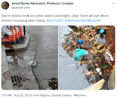
Smoke clears out at 4pm in ReginaForest Fires (FireSmoke.ca)
 Storm drains had to be cleared out this morning after heavy rain and thunder overnight in Regina.
Smoke clears out at 4pm in ReginaForest Fires (FireSmoke.ca)


 Wind gust profiles suggest a late system causing problems in southwest Saskatchewan up to 11pm
Extremely low visibility at midnight

Wednesday, August 09, 2023
Moderate Risk Day 2 Thursday, August 9th, 2023
Moderate Risk Day 2 Thursday, August 9th, 2023
Be READY for #skstorm tomorrow!
Technical discussion:
Two different scenarios featured by today's short and mid term forecast models. The hrrr shows more convection with storms over Regina, the NAM Nest is showing little to no convection for the city. Both models agree that the Estevan region will be in the DANGER ZONE from 4pm to at least 8pm. Regina might see more tornadic storms form later in the evening or overnight (7pm to 9pm and 1am). With experience of watching these patterns fold and unfold, our best guess is to put all of southern Saskatchewan on storm watch with southeastern areas ready to be on high alert in cast heat energy continues to over take the extreme humidity. Lack of ground water to the west will stir up winds, extreme humidity in the east may trigger tornadoes with this system.
Enjoy the weather, pray for rain and stay safe!


Tuesday, August 01, 2023
New Playlist: Old Music New Videos
Check out our new playlist on YouTube, all the new videos with old music will be showing up here:
Subscribe to:
Posts (Atom)