Sunday, May 28, 2017

Saskatchewan/Manitoba Windy Today, Monsoon For Bangladesh... [GLOBAL WIND MAPS]

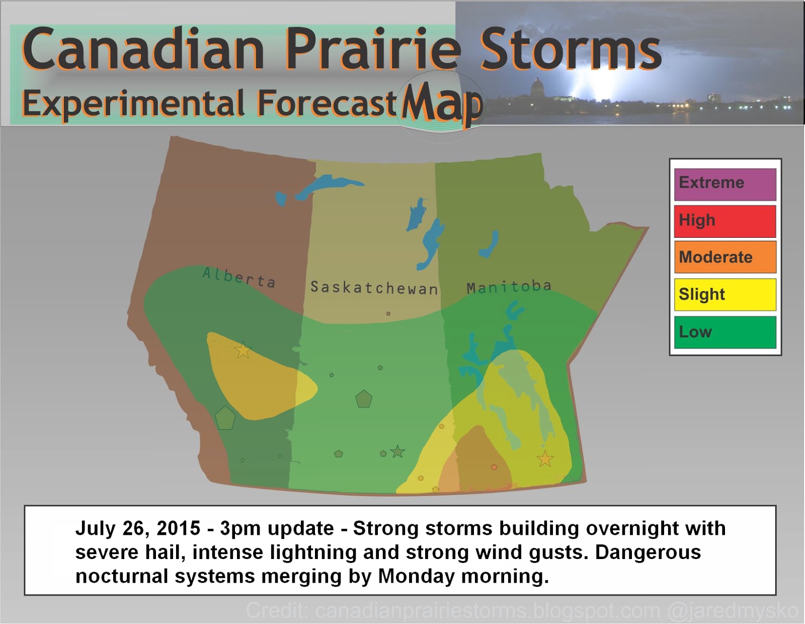
It is a fairly windy day today in Saskatchewan and Manitoba and some garden type thunder showers may affect isolated areas this afternoon but nothing special.

Looking at the global wind map, the rest of North America is fairly calm. The strongest winds on Earth right now are all surrounding the continent of Antarctica, with maximum sustained winds of 89km/hr. In the Bay of Bengal, a Tropical Cyclone is forming into a Monsoon with current maximum sustained winds of 64km/hr. Landfall is expected for Bangladesh and Myanmar this week. The calmest continents on Earth right now are Africa and South America. Here are some snaps of the current wind maps around the globe as of 2pm SST for comparison.

Wednesday, May 24, 2017

Inland Cyclone Taking Shape (World Animated Wind Map)

Check out this incredible image of the "Inland Cyclone" as it begins to take shape.


See the current map with animated motion here:
Earth Wind Map

Remember to bookmark our data links page as this link and more are saved there.
Data Links

Tuesday, May 23, 2017

Inland Cyclone Hits Wednesday

Looking at the latest GFS forecast model, an area of southern Alberta between Calgary and Medicine Hat will be the focus of a major wind storm on Wednesday. Peak sustained winds of 73 knots or 135km/hr are showing up as of 0z or 6pm local time. Tree and property damage begin to occur at 80km/hr which is the criteria to issue wind warnings by Environment Canada. This will go way above and beyond that so widespread power outages and major widespread damage will occur across most of the province. A special weather statement is already in place for the region and expect warnings to be issued very early so people can prepare. To put this into perspective, 135km/hr winds would make this a category 1 hurricane but since it is on land, it is considered an "Inland Cyclone".


In the graphic above, the purple area is 135km/hr, the red covering most of southern and central Alberta is 90 to 130km/hr. The yellow, which will affect nearly every area from Alberta to Manitoba is 55 to 90km/hr sustained winds. It is expected to last a strong two to three days and weaken by Friday. Keep in mind, this is just a model estimate and strengths and locations may shift. Wind gusts will be stronger, heavy rain and a drop in temperature is also expected. Check your local forecast and read all statements and warnings closely.

Thursday, April 27, 2017

Storm Season Gets Closer - May 6th?

Long term forecast models are showing a brief heat wave across Alberta and Saskatchewan, peaking May 6th with possible high temperatures of 26C. A cold front following off the mountains seems to suggest action within the supercell composite as well in west central Alberta. Certainly no guarantees on the timing, location, or intensity but something to note. Maybe just a glimmer of hope or maybe there will be some big storm action. By the looks of the map, the heat goes very far north into both Saskatchewan and Alberta. Remember, that is May 6th, a full 9 days out.


Image via http://weather.cod.edu/forecast/

Wednesday, July 20, 2016

Supercell Sunset and Lightning Strikes!


July 19, 2016

Regina, Saskatchewan


Between 8pm and 10pm I caught this incredible display of Saskatchewan's skies. A tornadic supercell to the north provided incredible sunset shots from near the RCMP Heritage Centre. Later, dry cg lightning strikes as seen from the south side of Wascana Lake.


Tuesday, July 19, 2016

Continuous Lightning 3am July 19, 2016


Just after the near zero visibility downpour, I caught some clips of continuous lightning flashes over downtown Regina after 3am. It was severe warned for about an hour but only produced the heavy rain for a few minutes, no hail or much wind. More of the same today and tonight!?

Monday, July 18, 2016

Southern Alberta! Be Prepared Tonight... #Supercells #Tornadoes #abstorm

The BIG storms are back today! Great heat energy combined with several days of seeding rains and a strong jet stream will fire off some huge storms in southern Alberta late in the day and run east overnight, maintaining power. Potential for very large hail and long track tornadoes exists but for the most part, it will be hot and sunny all day for most areas. We don't expect storms to "break the cap" until late in the day or maybe early evening but when they do, it will get vicious! Overnight, nocturnals will grow and cruise east into Saskatchewan setting up an even more powerful set up on Tuesday. Tuesday night into Wednesday the strongest of this system will show its teeth over eastern Saskatchewan and southern Manitoba. This is a system to take very seriously. Charge you devices and set your weather radio to ALERT. Here is the current risk map:

Saturday, July 09, 2016

Regina North Storm Timelapse 3:39 to 4:11pm

Overnight and Saturday Morning Risk Map

Here is an updated risk map for overnight and into Saturday morning. Next update at 7am. Strong thunderstorms overnight will increase in scale and intensity by morning. Large hail, strong winds and risk of a tornado for south east Saskatchewan and south west Manitoba. Saturday evening, storms will become long track supercells with significant tornadoes and up to baseball size hail.

Friday, July 08, 2016

Moderate to High Risk Saturday and Sunday #MBSTORM #SKSTORM

Saturday and Sunday looks like it will be a moderate to high risk for severe weather in south east Saskatchewan and southern Manitoba. Baseball size hail with long lived supercells, significant tornadoes, dangerous lightning and damaging winds. Begin your tornado precautions NOW if in these areas, Yorkton south through Regina into Montana, east to the Red River Valley and all of south west Manitoba. Make your plans now and stay safe, monitor weather alerts closely and with full attention, charge weather radios, cell phones, and stock candles and food.
A detailed map will be outlined later tonight as models come in line with the forecast.
Here is the Saturday 6pm NAM Supercell Composite:

Sunday's GFS shows the Supercell Composite Index with soundings at 69.1 (translating to a PDS Tornado, "Particularly Dangerous Situation) just south of the Saskatchewan/Manitoba/North Dakota border intersection:

Tornado #5 of 2016 Confirmed

Video of Saskatchewan's 5th confirmed tornado of 2016 near Estevan yesterday July 7.

Wednesday, June 29, 2016

#abstorm More Small Hail In Large Amounts Today - #mbstorm Landspout Tornadoes

Copious amounts of moisture across the southern prairies today combined with high temperatures will combine to mix in a little of everything, or lot of little things. Yesterday reports out of Okatoks, Alberta showed huge amounts of small hail covering the highways as snow plows had to be called in for what is quite a normal major hail event for the foothills as summer storm season hits its prime time of late June (pictures and tweets below). More of the same is forecast for today with an added bonus of a possibility of landspout tornadoes in southern Manitoba, especially in the Red River Valley. Strong pulse storms will begin early in the day with some becoming near supercellular size in areas south and east of Red Deer Alberta. Southern Saskatchewan could also see some storms reach severe levels with hail and heavy rain as the main factors. Here is a forecast map as drawn up at 7am: This map may be updated as needed later this afternoon. Photos and tweets from yesterday's amazing hail storms in the southern Alberta foothills:

Monday, June 27, 2016

NWT - Storms Way Up North Today [Risk Map]

Storms way up north today. North West Territories regions under an active severe thunderstorm watch. "1:14 PM MDT Monday 27 June 2016 Severe thunderstorm watch in effect for: Hay River Region including Enterprise Conditions are favourable for the development of severe thunderstorms this afternoon and evening along the Mackenzie River and southern Great Slave Lake from Fort Simpson to Hay River. Thunderstorms are beginning to develop over the region. The thunderstorms will strengthen this afternoon, with hail to the size of quarters and damaging winds in excess of 90 km/h possible. Thunderstorms will weaken this evening." Public Weather Alerts for Canada: http://weather.gc.ca/warnings/index_e.html Here is today's Risk Map:

Friday, June 24, 2016

"Several areas to watch this afternoon.." [1pm Updated Risk Map]

Several areas to watch this afternoon for the development of severe thunderstorms. Heavy rain, flash flooding, large hail and intense lightning are the main concerns today and into the overnight. In the north, slow moving storm cells may trigger flash flooding and large hail throughout the afternoon and into the evening. Further south, mainly in south western Manitoba, a strong cold front will trigger supercells late this afternoon and move east overnight. Extreme amounts of precipitation with large hail and possible microbursts could cause localized damaging wind gusts. Very intense lightning will also be of a concern, especially near game time in Winnipeg as the CFL season kicks off there tonight. Here is the latest detailed risk map for today:

Friday, June 17, 2016

Daytime Clearing - Nighttime Derecho [Saturday's Risk Map]

With clear skies expected across the prairies on Saturday, daytime heating will to lead to severe weather developing overnight and into Sunday. Strong damaging winds and heavy rain with flash flooding are the main concerns. The situation may in fact become a "derecho" type event.
(A derecho (pronounced similar to "deh-REY-cho" in English, or pronounced phonetically as " ") is a widespread, long-lived wind storm. Derechos are associated with bands of rapidly moving showers or thunderstorms variously known as bow echoes, squall lines, or quasi-linear convective systems.) Source: http://www.spc.noaa.gov/misc/AbtDerechos/derechofacts.htm
Along the international border, storms are expected to be strongest and move east at a minimum of 80km/hr. It will move so fast that the storm system will start up in Montana Saturday night and end up in northern Ontario on Sunday morning. Since these powerful type of systems can cause widespread damage with gusts of between 100 and 120km/hr, areas near or around the main storm system will be affected. Heavy rains with supercell thunderstorms will precede the damaging wind event. Tornadoes and large hail are also possible ahead of the squall line.
Here is the latest graphic from the GFS storm model showing midnight Saturday's Supercell Composite Index:
As you can see in this second snip, the strongest areas of strength move all the way into northern Ontario by noon Sunday, only 12 hours after the first graphic, seen above.

Our preliminary risk map, outlining the area of most concern for Saturday night:

Wednesday, June 15, 2016

Incredible Shelf and Lightning Photos and Video - June 14, 2016

Timelapse from 64x to 16x all footage shot between 9 and 10pm on June 14, 2016
Incredible Shelf Cloud with lightning over Wascana Lake and the Saskatchewan Legislature in Regina this evening just before 10pm
All footage by +Jared Mysko Storm & Wildlife Photographer Adventurer @jaredmysko

Today's Risk Map

Storms from Montana may drift into south eastern Saskatchewan and Manitoba and become marginally severe later this evening. Heavy rains in north central Alberta and general thunderstorms in northern Manitoba.

Saturday, June 11, 2016

Today's Risk Map - "Extreme Instability"

Something to keep an eye on today... extreme instability along the international border should keep the risk of tornadoes about the Montana/North Dakota/Saskatchewan border intersection. The heavy rains are expected in south western Saskatchewan this morning and burn off with day time heating. Storms will fire up later this afternoon in Montana and remnants could drift into the southern most area of south east Saskatchewan. Risk of storms will be highest after 6pm for Estevan.

Thursday, June 09, 2016

Today's Risk Map: #skstorm #mbstorm

Moderate Risk for areas along the southern Manitoba/Saskatchewan border. Chance of a tornado, large hail, damaging winds and intense lightning. Storms are expected to initiate rapidly around 3pm in south east Saskatchewan and strengthen as they move northeast into southern Manitoba. Peak intensity of these storms will be between 3pm and 8pm.

Wednesday, June 08, 2016

Storms Ramping Up Today, Look Out For Tomorrow!

Widespread severe thunderstorms late this afternoon, strengthening into the evening and then running all night. Hot and humid air today will give rise to strong thunderstorms including supercells with golfball size hail and wind gusts up to 100km/hr. On Thursday morning, the remnants of today's storms will quickly emerge in south east Saskatchewan and move into southern Manitoba with near maximum force. This will be a dangerous situation. Areas from Yorkton to Winnipeg should prepare now for extremely severe weather tomorrow afternoon and into the evening.

Tuesday, June 07, 2016

Moderate Risk Today: Calgary Area [Today's Risk Map]

Moderate Risk today for areas along the dry line between Sundre and High River, Alberta. This carries a risk of an isolated tornado to go along with supercell thunderstorms reaching strengths of 110km/hr wind gusts and hail up to 4cm or an inch and half. Take all Environment Canada warnings and watches seriously today and stay extra weather aware if you are in areas along the foothills of Alberta today.

Monday, June 06, 2016

Busy Week Ahead! Lets Start In Alberta...

High based supercell thunderstorms in west central Alberta today with risk of golf ball size hail and wind gusts up to 100km/hr. #abstorms This system is expected to gain strength as it comes off the foothills and cross the prairies this week. The risk moves south east tomorrow into southern Alberta and western Saskatchewan. Long term forecast models have shifted Wednesday and Thursday back and forth between Manitoba and southern Saskatchewan for an enhanced risk of extremely severe thunderstorms. We continue to monitor the situation closely but for sure something big is brewing for later in the week.

Saturday, May 21, 2016

Updated Risk Map 6pm SST #skstorm

Rapid expansion northwards of severe thunderstorms in Montana at the moment. Updated risk map as of 6pm SST laying out a slight risk for mainly south west Saskatchewan. Latest storm forecast models suggest storms will track north towards the Kindersley/Rosetown region this evening and dissipate in strength.

First Big Storms Saturday In Saskatchewan #skstorm [Risk Map]

Strong to damaging winds will be the main issue over most of southern Saskatchewan on Saturday. Thunderstorms may become severe with intense lightning, strong wind gusts and brief downpours of rain. These storms are expected to emerge late in the afternoon in extreme south west Saskatchewan and slowly track east into the evening. A very marginal tornado risk does exist as well as a chance of hail reaching severe levels very briefly within the strongest cells. Next update, around 2pm.

Remember to follow Environment Canada watches and warnings for the latest and follow "Storm Tweets" as they come in via our blog: http://canadianprairiestorms.blogspot.ca/p/weather-data-links.html

Tips: Be prepared and have a safety plan in place. Have your weather radio, cell phone, cameras, candles and flash lights charge and at the ready.

Stay safe and enjoy the weather!

Thursday, May 19, 2016

Today's Forecast Show #skstorm Saturday?

Here is the archive of our Severe Weather Forecast Show, originally aired via Facebook at 9:30pm Thursday, May 19, 2016

Severe Weather Forecast Show - May 18, 2016

Here is our second Severe Weather Forecast Show that was broadcast yesterday evening via Facebook. Looking at the coming storm situation this weekend and possibility of big storms in Saskatchewan on Saturday. The next show is scheduled for 9:30pm SST tonight for another update on what the forecast models are saying.

Be sure to like and bookmark us:
https://www.facebook.com/CanadianPrairieStorms/

Tuesday, May 17, 2016

Monday, May 09, 2016

Extreme up-close video of tornado near Wray, CO! (May 7, 2016)


Video courtesy of @reedtimmertvn @accuweather

Filmed on May 7th, 2106 near Wray. Colorado

This looks to be tornado of the year so far but its still very early in the season.


Another perspective of this tornado can be seen via 360° video:

https://www.youtube.com/watch?v=TCXp9Y5uPn4


Much Needed Rain!

Most of Alberta and Saskatchewan have been under extreme danger for forest and grass fires for the past few weeks and finally this week will bring some much needed rain. Thunder and lightning of the garden variety may accompany this system as it crosses the prairies. Significant precipitation will mostly be confined to the south as the north will remain under extreme danger of forest fires. Higher humanities may help in controlling these fires.

Here is our first map of the storm season: (graphic design format may be updated in the coming days)


Thursday, April 14, 2016

Alberta Canada's First Tornado in 2016


Video of the first tornado on the year in Alberta yesterday, EF-0 confirmed by Environment Canada. 
via YouTube - Shawnah Moseley

Sunday, July 26, 2015

Storm Systems Merging Overnight - Extremely Dangerous Situation On Monday

All signs are pointing to a very dangerous situation on Monday across southern Saskatchewan and southern Manitoba. Heavy rains, flash flooding, large amounts of precipitation are expected from Swift Current to Brandon starting early in the morning from nocturnal thunderstorms that may become strong to severe late tonight. Strong tornadic supercells are expected along the North Dakota/Saskatchewan/Manitoba borders early in the afternoon. Systems from Alberta will be moving quickly eastward while Manitoban storms will drop south and collect in a back-building formation in North Dakota. By early afternoon, it is expected both systems will come together over south eastern Saskatchewan with strong tornadic supercells moving north across the border from North Dakota.

Please monitor Environment Canada Warnings closely. This may become a very dangerous situation. Forecast models may change locations drastically overnight depending on how things line up. Have a safety plan ready but remember, this is only a forecast. Updates to the risk area map will be posted as required and please remember to keep reports to a workable minimum with accuracy of location and size of hail using coins or measuring device in photos. Rapid rotation reports are always best served with a short video when in a safe location.

Here is the forecast map for this evening and overnight with tomorrow's expected outlook "Day 2":


Wednesday, July 22, 2015

Updated Risk Map - 2:30pm - Severe Weather Outbreak In Progress

Here is the updated risk map as of 2:30pm:


Just after noon time in Calgary and flurry of funnel cloud reports came in. As of right now, the main system has exited city of Calgary and is still growing and moving east. No confirmed tornado touch downs but many photos suggested it very close. Large hail and downpours were also reported.

Here is a zoomed in view of Calgary radar as of 1:50pm - Two dangerous areas, both seem to be rotating on radar. Northern circle is much wider/slower, while the southern circle is the funnel producers with much tighter/faster rotation and the main area to watch. South east corner of a east bound tornadic supercell is usually where it will produce tubes.


Twitter #abstorm highlights from earlier this afternoon:


Tons more can be seen via the #abstorm feed on the right side of this page.

Also, the latest updates will be posted on our Facebook page.
Please like, share, comment and post your footage when safe to do so.

Storms are moving east and expected to continue all afternoon and late into the evening.

Tuesday, July 21, 2015

Today's Outlook Map [Moderate Risk] - Plus: Yesterday's Summary Of Events

Here is today's severe weather outlook map:


Storms should begin to fire up early this afternoon and last late into the evening. Large hail and damaging wind gust will be the main feature of today's storms.

Yesterday afternoon, storms started extremely strong with two main cells (Lethbridge and Edson) both going purple on radar from the beginning and producing reports of hail the size of golf balls or slightly larger. After initiation, these storms morphed into a linear MCS (mesoscale convective system) producing intense lightning and incredible shelf structure, losing most severe qualities before hitting the city of Edmonton.

REMINDER: When reporting hail to #abstorm #skstorm please use a measuring tape, ruler, coins or golf ball, baseball, softball, etc.. Accuracy in measurement is very important in determining potential damage and risk to future regions. Photos of holding hail in your hands is not acceptable as people have different sized hands. Another common mistake is reporting marble size hail. Marbles also come in various sizes. If it is very small hail, please report as pea size.

***The best way to report is taking a photo with a measuring tape held beside the hail stones***

Here are some tweets of the action in Alberta last night:


Saturday, July 18, 2015

Nice Looking Waterspout In Manitoba Today.

Incorrectly being reported as a tornado, this is a beautiful waterspout. See Weather Glossary below.


A waterspout was photographed today over Interlakes in southern Manitoba. At no point was it over land so this is a confirmed waterspout.

Environment Canada's Weather Glossary:
Waterspout
"A waterspout is a rotating column of vapour and water which extends from thundercloud to the water's surface. A waterspout looks like a tornado but is much smaller and weaker. The diameter of a waterspout ranges from seven to 20 metres and its winds from 40 to 80 kilometres per hour which is strong enough to flip a boat. A waterspout may last up to 10 minutes. Waterspouts, for the most part, form over some of the major lakes of southern Canada during periods of cool, unsettled weather, usually from mid-summer to mid-fall."


Thursday, July 16, 2015

July 16, 2015 - Severe Thunderstorm Hits Regina [Four Videos]


A very busy day around the province of Saskatchewan started with juicy forecasts and lots of anticipation.

http://www.canadianprairiestorms.blogspot.ca/2015/07/todays-outlook-map-dangerous-weather.html

Just after noon as the hot sunshine peaked, southern gulf stream appeared and the cold front began to threaten, storms started to fire off, all across central Saskatchewan. With temperatures of only +8C in Cypress Hills and +15C in Kindersley, the heat wave finally met its match, knocking down weeks long 30 degree days. From northern Saskatchewan which collected large piles of small hail, supercells quickly filtered south. Warman was first with nearly 1 inch or toonie size hail. Then, another new set of cells formed further south with Davidson reporting gold ball size hail. Between 2 and 3pm, the entire province filled out with clusters of supercells. Two were seen east of Regina as captured in our timelapse video. Then just as things seemed to clear out, the weather radio blared out an alert and a sudden storm cell popped up right over the city of Regina.  Luckily no major damages here but more storms are forecast again tomorrow, further east.

Wascana Lake Storm Timelapse (15 minutes in 15 seconds)

Today's Outlook Map - Dangerous Weather Ahead!

Current conditions are showing a lot of potential with a strengthening southern gulf stream, cold front coming in from the west and lots of rain in the north. Prairie and Arctic Storm Prediction Centre mentions a possibility of tornadic supercells south west of Saskatoon later today. Otherwise, a straight line damaging wind event with supercells associated with the cold front will cross the province of Saskatchewan very quickly and land in southern Manitoba over night. Large hail and heavy rains are expected further north. Please head all warnings and take precautions. Loose objects should be secured, now and candles gathered/phones charged. This is a serious situation! Storms may not begin until late in the day but when they do, they are expected to cause damages with power outages likely in highly populated regions of Saskatchewan.

Here is the latest outlook map:


Wednesday, July 15, 2015

Today's Outlook

Prairie Storm Prediction Centre has removed the tornado wording from its 2pm forecast update. As well, the RAP forecast model has suggested the tornado threat has passed for today. The NAM is usually a little bolder and over done as a forecast model and keeps a slight chance of tornadoes open. Both, agree that supercells will be active over much of southern Manitoba today creeping a bit into south eastern Saskatchewan. Central Alberta will see active thunderstorms as well. Mainly heavy rain, large hail and strong to damaging winds.


Tuesday, July 14, 2015

This Week's Outlook/NEW Government Issued Twitter Alerts

Environment Canada announced today that they have officially created Twitter accounts for each weather region in Canada. You can see the list at the link provided below as well as the official news release.

Follow and turn on mobile notifications here:

Twitter Accounts by Province/Territory

Regina currently has 104 followers
Saskatoon 60
La Ronge 4
Moose Jaw 42
Calgary 178
Edmonton 152
Toronto 199
Montreal (E) 91
Montreal (F) 170
Winnipeg 45
Vancouver 55
Lillooet 3
Halifax 49

 Let's get these number up! Get informed.

Here is today's severe weather outlook map:


Storms are expected to become more organized and strengthen beginning later today. Stronger storms on Wednesday through Friday with a possible moderate risk for southern Manitoba.

Saturday, July 11, 2015

Central Saskatchewan Storms

Storms have been building all morning around the Regina area and just after 11am the lightning detector began to burst with numbers. Strikes per minute climbed from 60 to 90 to 120 to 220 in the span of about 15 minutes. Here is a screen grab from NWR Weather Lightning Detection as of 11:22am:


These thunderstorms have extreme heights of 50k foot tops which gives them huge power and potential for very large hail and heavy downpours to go along with intense lightning. Here are the echo tops as of noon:


Today's Severe Weather Forecast Map:


Friday, July 03, 2015

Massive Supercell Exploding Right Now Over Meadow Lake!

Many other cells now popping up further south towards Saskatoon and into south central Alberta. Here is a look at the current Echo Tops radar as of 2:10pm:


Updated risk area map:


Closely monitor Environment Canada warnings if in the risk area and take cover if a storm approaches. These storms will be damaging and dangerous. Stay safe!

Thursday, July 02, 2015

Big Storms On Friday And Saturday

As the forest fire smoke thickens once again over southern Saskatchewan, a major change in the weather patterns is about to occur. Today's northerly smoke filled winds will shift from the south on Friday, bringing heat and moisture to the prairies. Already like a simmering pot of soup, the air will be ripe for supercell thunderstorms to take over the weather picture for the next two days.

On Friday, central and southern areas of Alberta will be the focus of very high CAPE values (Convective Available Potential Energy), combined with a south east wind and a cold front diving in from the north the mix will be potent and result in some very strong thunderstorms with super cell structure, damaging winds and very large hail.

Here is the preliminary forecast map that may be upgraded or downgraded depending on the situation:


*Forecast models are not in agreement as the NAM is suggesting a major widespread event and the GFS is forecasting a much more subdued storm complex. Again, forest fire smoke could factor in and limit convection but we will have to keep on the safe side and calls em like we sees em...

Here is the map for Saturday, again things may not be as they seem to suggest:


As always, stay safe, be prepared and stay tuned to weather radios and Environment Canada watches, warnings and weather advisories.