Inland Cyclone Hits Wednesday
Looking at the latest GFS forecast model, an area of southern Alberta between Calgary and Medicine Hat will be the focus of a major wind storm on Wednesday. Peak sustained winds of 73 knots or 135km/hr are showing up as of 0z or 6pm local time. Tree and property damage begin to occur at 80km/hr which is the criteria to issue wind warnings by Environment Canada. This will go way above and beyond that so widespread power outages and major widespread damage will occur across most of the province. A special weather statement is already in place for the region and expect warnings to be issued very early so people can prepare. To put this into perspective, 135km/hr winds would make this a category 1 hurricane but since it is on land, it is considered an "Inland Cyclone".
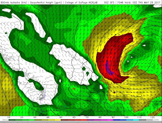
In the graphic above, the purple area is 135km/hr, the red covering most of southern and central Alberta is 90 to 130km/hr. The yellow, which will affect nearly every area from Alberta to Manitoba is 55 to 90km/hr sustained winds. It is expected to last a strong two to three days and weaken by Friday. Keep in mind, this is just a model estimate and strengths and locations may shift. Wind gusts will be stronger, heavy rain and a drop in temperature is also expected. Check your local forecast and read all statements and warnings closely.


No comments:
Post a Comment