Play by Play Commentary on Local and International Weather Events Documentation and Relay Alerts of Severe Weather Events from Regina, Saskatchewan.
The Source Since 2002
Wind gust danger early this evening as the strongest storm system of the year is beginning to rear its ugly head in southern Manitoba. This system produced a violent, public and damaging tornado event in Alberta in the afternoon and a top secret microburst or tornado north of Regina on Saturday evening. Eccccccccccc says its a high risk in southeastern areas of Manitoba. Echo tops show a discrete supercell that had popped up a little further west than expected. Again, those downstream of tornadic supercells are in grave danger. Take extreme precautions, watch the weather and stay safe! (We will process the secret footage tomorrow and post all the incredible highlights of this season in the coming days, boring weather ahead for at least the next two weeks)
June 23rd, 2022 Comprehensive Summary of this Spectacular Epic Tornado Warning Fest, Hail Shaft Frenzy, Gustnado Apocalypse with Mammoth Sized Popcorn Clouds followed by the Orange Peel Mega Shelf Cloud and a Vigorous Lightning Engine Supercell that had no quit!
Saskatchewan Storms and Wildlife Wonders on YouTube:
A timeline of events from the top of the May 2022 full moon cycle, it all started with this foreshadowing sign from the clouds east of Wascana Lake spotted on May 16th 3:36pm.
Hoping to see something pop up over Wascana Lake, filming began..
(for more, read the descriptions on the YouTube videos)
— CTV Morning Live Regina (@CTVReginaLive) May 18, 2022
To calculate the speed of the wind here all you have to do is know the distance between power poles and the speed of the debris that covers that distance. IF PowerPoleDistance=100m AND Debris speed is 3 seconds THEN it takes 30 seconds to go 1km WHICH = 120km/hr .. That is the speed of the outer bands of wind. The inner core of the tornado is obviously much higher, this looks like an EF3 which would correspond with similar events in Michigan from the same system. Environment Canada gave it a preliminary rating of EF0 because there were no reports of damage (unless SGI was to share information of course). The Western Ontario University Northern Tornado Project report can be viewed here: https://uwo.ca/ntp/blog/2022/landspout_tornado_near_caron_sk.html
As it super cooled off, another brief filming session with Kestrel temperature close monitoring as we saw it drop from 15C as the first sunshine came out after the rain, to 9C in about an hour!
May 18th
On Friday, May 20th, an EF3 tornado ripped through Gaylord, Michigan killing 2 and injuring 40. Here is some of the highest level damage and an historic "wood through steel" photo:
This shockingly powerful storm ended up ripping across 1000km of the most populated areas of Ontario and Quebec including Toronto (121km/hr), Peterborough (130km/hr), Ottawa, Montreal and Quebec City. At least 5 were killed, unknown at this time the damage or total injuries. Historic Derecho for sure.
EDIT: Many videos have been taken down by YouTube, text remains but some of these are old broken links.
I have gone through YouTube and made a list of all the videos with significant footage of the historic August 31, 2021 Storm the hit the city of Regina. This was the closest we have come yet to capturing the return of "Regina Cyclone 2.0" Please excuse the video thumbnails, for they are hilarious but quite fake. The footage inside the videos is real, I have reviewed it all. Each of these video shows a different angle of this epic storm.
Apocalypse of Stones in Canada! 🚨 Hailstorm struck Regina, Saskatchewan
This video shows a funnel with dust coming up of the ground which usually is enough to confirm an EF0 tornado. Tornado starts at 1:12 in the video. Travel With Costy's YouTube Channel:
SCARY THUNDERSTORM WIT HAIL STORM IN Regina, Saskatchewan. CANADA
Another weak funnel can be seen crossing over downtown from the CBC sky camera. Tornado / funnel starts at 0:25 in the video. Recommend slowing down the frames in the options on YouTube.
Real close to a tornado, mostly funnel. Amazing view from right under the cloud I was filming much further back on the lake. From Brandon Mazenc's YouTube channel:
Possibly the closest footage by chasers of rotation trying to turn into a tornado. Also, check out the tight funnel at 7:01 nearly a tornado right in front of them. Credit Manitoba Storm Chasers YouTube Channel:
I can't possibly post every video on YouTube here so here is a list of videos I made which eventually be part of the movie in the making Regina Cyclone 2.0
Watch towards the end as incoming rain send dusts into the air over downtown Regina. I was filming on the south shore of Wascana in front of the Legislature, the downtown core is the bank of lights on the right side of the horizon. A kayaker happened to have parked right there and we had a nice chat as he docked for the night. Rain was quite steady and moderate to light with no flooding seen on the way home afterwards.
Looking ahead to July, a heat wave from California to British Columbia will eventually make its way over the mountains and onto the prairies. We are looking at July 2nd and 3rd as the next chance to see big time thunderstorms on the Canadian Prairies.
Remember to check our Facebook Page for updates, the daily Thunderstorm Outlooks are now being updated and be sure to check the side bars (desktop version) for the auto updated images and Storm Chaser Tweets.
It is unusually dark out in Regina this morning, expecting things to clear up fast near noon with big storms to the west. Here is some early morning discussion before official things get issued:
Looking at the difference between the Hrrr and NAM Nest forecast models, the Hrrr seems to be confirming current radar and if it continues we will see much stronger storms to our west, Moose Jaw is going to be flooded (4 inches/10cm) Regina (1 inch/3cm).
Winds over 150km/hr at the Montana border will be pushing things towards us, new model runs keep suggesting tornadoes will be possible around Old Wives Lake, likely to the south and east of there after 5pm... expecting tornado watches any second..
Here is a playlist of videos from our YouTube channel from the Hurricane Force Blizzard that hit Regina, Saskatchewan on January 13 with aftermath video from the 14th, 2021.
"Heavy rain, freezing rain and well above normal temperatures began an historic day for the city of Regina, Saskatchewan. Wind speeds over 140km/hr were recorded just south of the city. Sustained winds over 94km/hr lasted about 3 hours 11pm to 2am. Widespread damage is being reported and cleanup is now underway. I went out for a couple walks during the storm and caught a few snow-nadoes and a lot of wild and scary winds!"
Expecting some non-severe thunderstorms this afternoon, I set up this timelapse at the edge of the city of Regina and then tracked back towards Wascana Creek. This is before and during the previously posted live stream at a small shelter along Wascana Creek: (6100 Brunskill Place in north west Regina). Ended up with only a few rain drops along my locations but radar clips saved on my Twitter page (@jaredmysko) show that it jumped the city again, and turned purple (60dbz) or near maximum strength just on the other side of the city.
Was fun, might do another one soon! Risk of thunderstorms until 8pm in Regina. Tomorrow the risk is in northern Alberta and its yellow, not grey like today. The really big storms will begin to cross the prairies with the increased heat this week, its gonna stay very active!
July 13th was a day to remember, still working on footage from this incredibly photogenic supercell that produced tornadoes (and "plow winds"?!) from the Kindersley to Eston to Craven areas of west central Saskatchewan. Here is a couple videos of "most" of the footage:
#skstorm#abstorm Weekend Outlook: There is a chance of non-severe thundershowers over southern Saskatchewan on Friday afternoon. More significantly, a trend of wet weather begins over dry grain belt areas which will knock down the risk of fire and provide much needed moisture to farmers. On Sunday, the first real chance of super cellular thunderstorm activity will be present in southern Alberta. This mean severe thunderstorm watches, the first severe weather outlook map and giddy storm starved chasers may suddenly appear out of their hibernation.
Note: There is a 1% or non-zero chance of isolated tornadic spin ups over south western Saskatchewan Friday afternoon. Highly unlikely to be of any significance but would not be right to miss mentioning.
Video included is the NAM Nest forecast model for 6am Friday to 6am Saturday, first clip is Simulated Reflectivity, second clip is Significant Tornado Index.
Footage by the World Record holder for tornadoes, Roger Hill of Silver Lining Tours. You know when he comes to Canada its gonna be a wild one!
"Incredible supercell producing 9 confirmed tornadoes in southern Saskatchewan on July 10th, 2018. None were extremely long lived, but they all were exciting to watch!"
August 3, 2018
One person was killed and a house was lifted off its foundation and destroyed along with numerous campers and vehicles in Alonsa, Manitoba on the shores of Lake Manitoba east of Dauphin. Incredible footage from several sources tweeted out photos and video of the event which was the first tornado related death in Canada since Goderich, Ontario in 2011.
The tornado in Manitoba touched down in Alonsa yesterday evening. Property on a nearby beach has been destroyed. Photos by Vanessa Lambourne Whyte. @CdnPresspic.twitter.com/odzR0QBHk6
Now that we are well into the month of June, "Storm Season" is fully underway on the Canadian Prairies. Almost daily severe thunderstorms in at least one of the three prairie provinces. Today is especially active as a short heat wave is being met with a sharp cold front in central Alberta. One tornado warning has already been issued in the area north west of Edmonton but has since expired. The risk for tornadoes increases into the evening with squall line likely forming over night which is expected to move into southern Saskatchewan on Sunday. Very large hail and damaging widespread winds are the main concern. Here is today's daily outlook map which we post here in the sidebar and on the Facebook Page
This will be updated again later tonight or early Sunday morning as the risk will shift mainly to south eastern Saskatchewan in the afternoon.
Here is the latest clip of the Echo Tops radar showing a massive complex of supercells with one in the south ringing in at over 50 thousand foot tops!
Oklahoma Storm Chaser Reed Timmer made the trip up north to try and catch a tornado and is posting on Facebook Live as you can see how it looks in this recorded video:
Many other chasers are out trying to get the best view and posting to the #abstorm hashtag on Twitter. You can see this live feed as well in the sidebar.
Also, here is a couple videos I forgot to post on the blog from May 30th storm in Regina. Most posts on the blog will be dedicated to specific events so follow the Facebook page and my Twitter for the most recent posts.
Full 15 minute episode:
Highlight clip:
Thanks. Remember to have a Weather Radio tuned to "Alert" if in the risk areas.
Enjoy the weather and stay safe!
Starting to get some storm action here in Saskatchewan, Over an hours worth of timelapse watching clouds form in the late afternoon. Caught a bit of lightning and mammatus in the evening. This storm system had some severe thunderstorm warnings in some areas but nothing major, yet. Our tornado season kicks off June 1st to August 5th, being the most active time of the year for severe thunderstorms and tornadoes on the Canadian Prairies.
Winter 2017-2018 was a very cold one for the most part with very few precipitation events in Regina. The drought continued in south east Saskatchewan and temperatures stayed below the -20s C for extended periods of time through January and February. Extreme cold warnings were commonplace nearly every week of the deepest part of the season. What precipitation did happen though, had some real punch. Two events will stand out as memorable for this past season.
First, the heavy rain and flash freezing January 9th which caused massive power outages, people skating on the streets, extreme danger on the roads, injuries that caused huge wait times at the hospitals and medical centres, and an epic amount of road salt and sand to drive up cleaning bills for the rest of the season.
Here is a playlist of videos from YouTube of the Flash Freeze event:
Besides a few light snow showers here and there, once March arrived a Colorado Low came in and changed everything! The week before it hit, there was nothing but dusty 1 cm deep snow off to the sides and completely dry roads and walk ways. It began slowly on Saturday, March 3 with a couple cm accumulated, then about 5 more on Sunday. A lot of people thought that it was done but in fact the snow was just gaining momentum and about to begin a major assault on the roads and sidewalks. This was "miracle moisture" for suffering farmers who feared the drought was only getting worse. 15 cm dumped on the city overnight Sunday and by Monday at noon we had 20 cm on the ground.
Another huge wave hit that afternoon, bringing the total past 30 cm. Monday evening the snow kept falling heavy, raising the total past 40 cm on my measuring stick. The final flakes overnight settled the accumulated total to about 43 cm on my rooftop deck.
Here is a compilation of videos from this epic and historic winter storm:
Final measuring stick readings, 42 cm / 13 cm on the ledge:
Here is a compilation of all storm videos from this past winter season:
Significant snow fell overnight in Regina and continues to accumulate. Up to 10 cm is expected in southern Saskatchewan by the end of the week. Much higher amounts in western Saskatchewan as areas in the central prairies could see well over a foot or 30 cm by the weekend. Stay tuned for updates on Canadian Prairie Storm Facebook Page and be sure to check the highway hotline before trying out the highways. RCMP are already reporting "very treacherous conditions".
As summer storm season shifts to the calm warm days of "Second Summer in September", here in Saskatchewan the weather is becoming uneventful and maybe even a little bit boring. Elsewhere it seems, extreme events have become the norm just in this past week. Let's go back a couple weeks when the first unusual event occurred on a large scale.
Monday, August 21, 2017
Solar Eclipse Crosses North America
Video from CNN on YouTube:
"The first solar eclipse to travel across the United States in 99 years began in Oregon and ended in South Carolina."
Monday, August 28, 2017
Hurricane Harvey Sits Over Houston Dropping Record Rains
From Twitter:
Here's a picture that gives some perspective on how bad the floodwaters are in Houston. pic.twitter.com/2p1NQcC6B0
Saturday, September 2, 2017
Nuclear Explosion Triggered 6.3m Earthquake In North Korea
From EuroNews on YouTube:
"Japan says the two shallow earthquakes which shook North Korea on Sunday were a nuclear explosion, following the sixth atomic test by Pyongyang since 2006."
Monday, September 4, 2017
Meteor and Fireball in British Columbia
From YouTube:
Wednesday, September 6, 2017
Hurricane Irma Begins To Destroy Islands
From YouTube:
Hurricane Irma became one of the most powerful storms ever as a category 5 with sustained surface winds of 160 knots/184mph/296km/hr.
Thursday, September 7, 2017
Once In A Decade Solar Storm
From SpaceWeather.com:
"A CME has just hit Earth's magnetic field (Sept.7th at ~2300 UT). This is the debris from Wednesday's decade-class X9 solar flare. It arrived earlier than expected, confirming that the storm cloud is both fast and potent."
Friday, September 8, 2017
Strongest Earthquake (8.1m) Since 1985 Hits Mexico
From YouTube:
Just off the south west coast of the Mexican state of Chiapas late Friday night, the death toll is already rising beyond 50 according to some reports.
If all that wasn't enough, forecast models have now confirmed the worst case scenario for the track of Hurricane Irma as it gathers strength over the hottest waters off the northern coast of Cuba. It is expected to make a direct hit on the entire state of Florida this weekend.
This is a slideshow of the progression of our "Severe Weather Outlook Map" this year. Starting out on May 31, you can see how we squared of the image for Facebook and massively updated the banner. June and July proved once again to be the peak months as August busted big time when a strong hurricane season became apparent. PASPC continued to make maps beyond July 31 until September 4 but it was mostly marginal storms. With extreme drought and heat in southern Saskatchewan, most of the action was confined to the Alberta foothills and central Saskatchewan this year. As another major hurricane begins to take over the news this week, we are reminded how we are all connected by the weather. Calm winds and southern heat are going to make for a second summer here in September as is often the case during very active hurricane years. Stay safe and enjoy the weather. For those who choose to move off the coast, away from the dangerous oceans, we have a lot of space and you are always welcome to move here or just visit. Thanks again for great year everyone!
Here is a quick post of as many tornadoes as reported via Twitter and Facebook. I expect much more will filter in over the next 24 hours and I will add them here. Peter Quinlan has a few more tornado videos on his timeline and you can check them out at this link: https://twitter.com/PQuinlanGlobal
Two more in eastern Saskatchewan, waiting for location confirmation (one was the Wapella tornado).
Couple tornados from yesterday in eastern Saskatchewan #skstorm photo's taken 28 minutes apart. Great day. Video later to come pic.twitter.com/j39ih79b0a
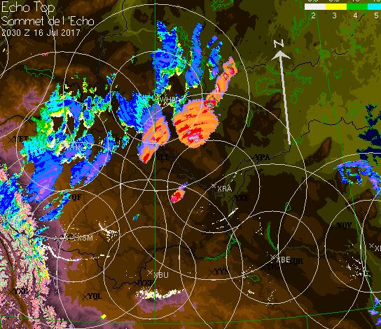
Sunday afternoon, July 16, 2017 storm energy was high across much of the province of Saskatchewan and tornadic potential was imminent. The 7am thunderstorm outlook issued by PASPC indicated a huge area to watch for strong storms across central Saskatchewan.
By 2pm it became clear that the risk had shifted well west of the original area of east central Saskatchewan as a massive supercell cluster had become severe thunderstorm warned in the Meadow Lake region. One lonely cell appeared west of Biggar at 2:10pm in a clear area between the rain complex to the north and extreme heat in the south. Only 20 minutes later that cell exploded to nearly reach maximum heights and severe thunderstorm watches were issued shortly there after.
As the afternoon Severe Thunderstorm Outlook Map was being built at that time, Saskatoon and area was added to the Moderate Risk area in orange.
Areas north east of Yorkton indicated the highest potential for severe thunderstorms by the forecast models but ended up not panning out. Later at night a strong supercell was creeping along the US/Manitoba border, helping to verify the high risk in that area. The main event ended up being between Biggar and Saskatoon late in the afternoon as tornado watches and warnings were issued between 4 and 6 pm. There was some severe sized hail and rotation indicated by radar but luckily no tornado touchdowns. The storm structure was absolutely jaw dropping. Here are a few Tweets from this event:
DALMENY AND MARTENSVILLE SK should be taking tornado precautions now. Dangerous tornado warned storm headed your way. #skstormpic.twitter.com/sVIjxL22eL
A high risk for severe thunderstorms was issued early Sunday morning for western Alberta with a chance of tornadoes and extremely large hail.
By 5pm one tornado was confirmed and reports of tennis ball sized hail were included in multiple tornado warnings throughout the evening, from Rocky Mountain House to Drumheller, Alberta.
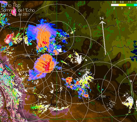
Storm continue to maintain maximum strength late overnight and by 11:30pm cells began to quickly pop up in western Saskatchewan. Here is an image grab of echo tops radar and lightning at that time:
A day 2 moderate risk was issues in the early afternoon and that is expected to be expanded by morning for most areas of southern Saskatchewan on Monday afternoon. Extremely large hail with damaging wind gusts and tornadoes. Link to PASPC Current Outlook
Many storm chasers are committed to converge on the area, such as the world record holder for tornado intercepts Roger Hill and his Silver Lining tour company. Also world famous storm chaser, Reed Timmer tweeted this: