Play by Play Commentary on Local and International Weather Events Documentation and Relay Alerts of Severe Weather Events from Regina, Saskatchewan.
The Source Since 2002
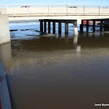
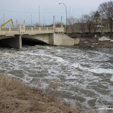
Click the photo above to see the map and all 63 geo-tagged photos from around the Regina Wascana flood zone. Below are some of the most significant shots of the day. Due to the early opening of the flood gates, areas downstream are much higher now compared to the lake relative to 2011 flood levels.
Video will be processed overnight and another trip around the lake before sundown will give a good indication of how fast things are developing with temperatures now over 20C.
Click the above photo to see the location map of 16 photos of the flood situation around Wascana Lake and Creek in Regina, Saskatchewan as of Thursday, May 2, 2013
Click the above photo to see the location map of 5 photos of the flood situation around Wascana Lake and Creek in Regina, Saskatchewan as of Monday, April 29, 2013
Click the above photo to see the location map of 11 photos of the flood situation around Wascana Lake and Creek in Regina, Saskatchewan as of Sunday, April 28, 2013
Click the above photo to see the location map of 11 photos of the flood situation around Wascana Lake and Creek in Regina, Saskatchewan as of Saturday, April 27, 2013
Click the above photo to see the location map of 6 photos of the flood situation around Wascana Lake and Creek in Regina, Saskatchewan as of Friday, April 26, 2013
The first severe thunderstorm in Saskatchewan occurred this evening with a warning issued by Environment Canada at 6:06pm for areas of the extreme southern portions of the province, Bengough, Willow Bunch and St. Victor. It was only severe on radar for a short time and the warning was dropped at 6:53pm. Other non-severe thunderstorms crossed the southern areas of the province this afternoon and these systems will turn to snow tonight. Moosimin, Yorkton and Kamsack areas of eastern Saskatchewan are now under a snowfall warning for up to 20cm of snow by Tuesday. "Wascana Jam" After the longest, harshest winter on record, the snow is finally melting and Wascana Lake is rising! Starting April 26th, each day we are covering this story as it develops. Here is the playlist of a series of videos being taken around the flood zone in Regina:
Since we have waited so long for spring to arrive, I decided to take some bread down to Wascana Lake and feed the birds. Only a few days ago it was rare to even see any birds around Regina but the last two days have proved they are back and populating the lake in a hurry! On Wednesday I estimated about a thousand birds on the lake and yesterday that figure easily jumped past a million. There was only one little area of birds the first day and Friday the entire lake was filled like I had never seen before. Feeding just a few birds got the entire flock to take flight in a spectacular display!
I shot a lot of video as it was such an amazing experience to stand there and watch. Look at the incredible difference two days make:
Here is Wednesday's footage:
Friday:
If you go, bring lots of bread and don't worry, if you run out they won't attack. haha
Video and photos from today as the sun finally came out for the first time in many days. According to news reports, we broke the record for snowfall in one winter season a week ago. Another 10 to 20 cm fell since to insure the highest total in recorded history for the city of Regina. Warm sunny weather next week will begin the next phase as the spring run off, melt and subsequent flooding will begin.
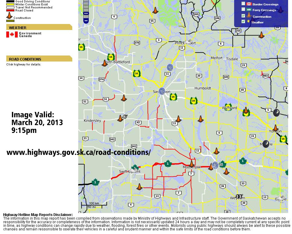
With a winter storm warning for most of south west Saskatchewan, the Highways Hotline is listing what could be a record number of highways closed at one time in the province this evening. Here is a screen shot of the highway conditions map, provided by the Government Of Saskatchewan's Ministry Of Highways:
#StaySafe !
Record snowfall for the year continues to add up today!
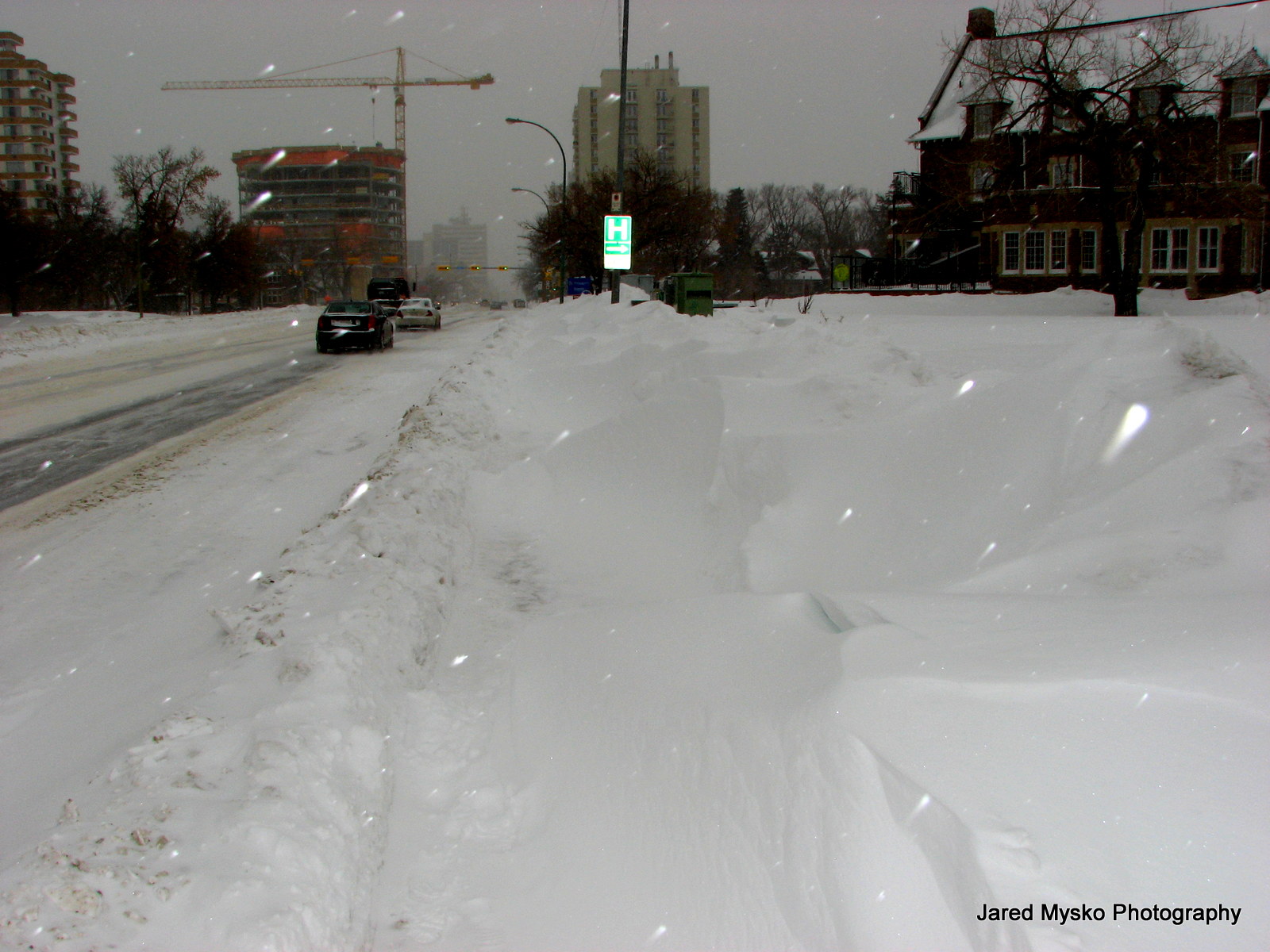
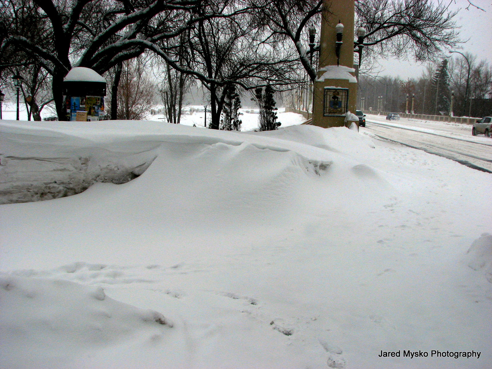
A walk in the park, more like a winter wonderland, around the north end of Wascana Lake to Albert Street where the highest snowbanks are found as the snow blows in off the lake. Then off to the Royal Saskatchewan Museum and La Bodega, home of the Ice Bar for a St Patrick's Day drink. This snow storm should officially register snowfall totals in the city of Regina at all time record levels.
Footage by Jared Mysko
@jaredmysko yes - I'm there playing a gig, and watched as the streets were coated in hail. One good crack of thunder too!!! Love it.
— Jeremy Sauer (@jjsweet) March 17, 2013
Getting more calls from the UK to use some of my footage of this... [from June 26, 2012]Some portions of this footage now seen on the BBC show "Nature's Weirdest Events"
All data collected via available information posted per site at time of publishing, please suggest edits if needed. All tours subject to availability, please check listed website for most current information, this spreadsheet is for research and comparison interest only. Tweet edits to @jaredmysko
According to several reports, the city of Regina is getting close to a record amount of snowfall for the winter year 2012-2013. Its tough to measure exactly how much snow has fallen so there seems to be some conflicting numbers out there. One thing for sure is, there is a lot of snow this year. Here are some photos from around Wascana Lake and the Saskatchewan Legislature:
Short clips of each event starting with melting snow in January to spring snowstorms, sunny ski-dooing, happy bunny rabbits, wild summer storms, tornadoes and random bird attacks. Ending with the Great Horned Owl and wall climbing at the Saskatchewan Science Centre. A year packed with adventure!
With appearances by storm chasers, Gunjan Shadow Hunter, @djhardwired Notanee Bourassa and other members of team Canadian Prairie Storms!
All footage and editing by Jared Mysko
Our new "Canadian Prairie Storms (v1)" Blackberry Application is now available in the BlackBerry World web store as of today for FREE! Be sure to download it before summer storm season starts as the price is subject to change, for now it is available for free, supported by the usual Google ads. This first version includes stories posted on this blog as well as "Category" links to YouTube video uploads and photos. This is the first version and will be improved upon as time allows. Feel free to comment, lend suggestions and help test the app in this BETA version stage. It is currently ONLY available to BlackBerry Smartphone, Playbook and Z10 users.
In other news, our big snow storm over the weekend was a big bust for the cities of Edmonton, Regina and Saskatoon as the system narrowly missed the major centres.
Video of the snow just beginning to fall in downtown Regina Sunday afternoon.
Calgary, Swift Current, Medicine Hat and Brandon all got slammed with heavy snowfall. Many highways in Saskatchewan were marked as "Not Recommended or even closed for a time on Sunday. The Number 1 highway west of Moose Jaw as well as the main highway between Saskatoon and Regina the Number 11 was also closed due to tractor trailers jack knifing and car littering the ditches.
Waiting for the storm that never came...
Snow Covered Highways On Monday
Remember to always check the Highway Hotline before venturing out onto the highways in winter!
7:10pm Radar Image Sunday, March 3
Here in Regina, a twitter storm was started with the tweet:
"@jaredmysko: Nobody should be on highways in S. Sask, anyone who is puts tow truck and fire dept rescue at risk."
After many replies and retweets, I feel it is important to stress that the point of that tweet was to encourage people not to take chances on the roads during a severe winter storm, especially after getting word that tow truck drivers were told not to go on the highway until it cleared up. I didn't mention EMS, paramedics, RCMP, or first responders so as not to clog of their timelines. I know they are all busy and I thank them for what they do.
As for the weather, it seems the heaviest snowfall hit mostly rural areas which is going to increase the risk of spring flooding and that could start as early as this coming weekend. Temperatures are forecast to jump well above freezing with bright sunshine and light winds. All this moisture is going to boil fast so expect a very active spring. This may not be the last of the major snowfall events in March and severe thunderstorms could be only a few weeks (and a lot of melting) away.
Heavy snow and high winds are causing blizzard conditions in areas of Texas, Oklahoma and Kansas today as a major winter storm deposits large amounts of moisture over the southern plain states. On Sunday Temperatures dropped from the 50s F down below freezing and into the 20s F shocking residents there. Amarillo, Texas reports 19 inches of snow on the ground. A state of emergency has been declared in 56 counties of Oklahoma as the system moves into southern Kansas. Blizzard warnings stretch across the Texas panhandle, north west Oklahoma, south central Kansas, and winter storm warnings are now up for most of Missouri, eastern Iowa and north western Illinois.
(check privacy settings for viewing videos from Facebook)
"
EXTREME blizzard footage from the Dominator 2 plowing roads and standing in 5 foot snow drifts near Woodward! 14-16" at least already!"
Meanwhile in Saskatchewan, people are enjoying warm temperatures and trying new ways to fool around in the snow. Check this video from today of a 'ski bike' jump:
"
The Storm Prediction Center in Norman, Oklahoma has listed 15 confirmed tornadoes from yesterday with a total of 87 injuries in tornadoes across Mississippi and Alabama. To check the full reports page click here... Also, the Hattiesburg, Alabama long track tornado has been rated EF-4 with winds estimated at 170mph!
With 13 confirmed tornadoes, some violent and heavily damaging, it will be a relief to know that no severe weather is predicted across Canada or the USA for the next 4 to 8 days at least. The monthly full moon cycle has wiped up some powerful stuff over the past few days. 5 injuries have been reported in today's tornadoes already and 15 fatalities plus nearly a million without power due to the snow storm that hit the north east Atlantic coast some calling it "Snow Storm Nemo". States of Mississippi and Alabama are still under tornado watches but the worst seems to have passed.
+ Kimberly Allen
"Snow plow driver so stuck he has to tell my neighbor who is watching from the house and wants to help but can't as there's to much snow to walk to the truck so snow plow driver gets snowblower from the back of the truck to make a path to talk to neighbor"
"Finally a happy ending as wife and family dog come to get snow plow driver out of ditch. I was concerned for a bit thinking she was stuck too but all was well."
This 30 day java powered image loop of snow cover data over the past 30 days, distinctly shows Montana and southern Alberta drying up as the north-eastern American states begin to get fully covered by snow:
Here on the Canadian Prairies, the depth of snow is shown in this graphic:
As of 01/02/13, snow depth appears to be greatest in a line from Estevan to Edmonton, east central Alberta, central and south east Saskatchewan. Surprisingly, the data for around the cities of Regina and Saskatoon seem to be opposite of what appears on the map. The city of Regina clearly has much more snow than Metro Saskatoon, yet the graphic suggests north west of Saskatoon has the largest snow depth. This is always a very important detail to factor in when predicting severe weather in the spring and summer as it can point out areas of major pooling of ground water below the surface than will not show up in computer meteorological forecast models. I'll be checking this data as it becomes available, likely once a month until full melt and spring flooding begins.
Jared Mysko
Images provided by Canadian Cryospheric Information Network - University of Waterloo and www.polardata.ca Credit: A. Silis, Environment Canada, 2013.
As the northern wing of "Winter Storm Nemo" hits Regina, Saskatchewan, one forecast model is suggesting up to 60 inches of snow for Boston beginning on Friday! So far, "Winter Storm Nemo" has dumped nearly 3 flakes of snow in Regina, much less than the originally forecast 2 to 6 cm. Seriously though, radar indicates that a few more flake will fall here tonight.
It sounds a bit silly to be trying to warn people about an impeding disaster when The Weather Channel names the storm after a Disney character. Naming storms after Disney characters seems to be a guaranteed fail for storm enthusiasts.
#Nemo
Alternatively, storms could be named by way of auctioning to prospective companies and the funds collected given to residents affected. Not to replace government disaster assistance funding but to immediately lend relief
#StormNamingAuction
For example (with a bit of tongue and cheek): "Tropical Storm McDonald's 100% Pure Beef is going to hit but everyone gets free cheeseburgers after :D
Save all of that for the next storm because this is a serious situation setting up for the east coast Friday and Saturday. One model suggests 50 inches of snow for Boston and anywhere between Toronto, Montreal and Boston will see this massive system come together. The Alberta clipper currently over southern Saskatchewan is expected to merge with another system from the south to drop record amounts of snow over Michigan, southern Ontario, Quebec, New England and New Brunswick. The city of New York and parts south should miss the bulk of snowfall as precipitation turns to rain.
Naming this winter storm "Nemo" has certainly got people talking about it, which is a good thing, however it may change the way we think of poor little Nemo forever, some may wish they never did find Nemo. :p
Jared Mysko
Here a playlist of video footage of the snowstorm that hit Regina this week:
Heavy snowfall warnings were upgraded to winter storm warnings for Regina and both Moose Jaw and Winnipeg got Blizzard Warnings on January 10th as it became clear that a major storm was beginning to affect the prairie provinces. After a foot or 30cm of snow fell, not including totals much higher in drifts, extreme temperatures dropped to -29C on Saturday, January 12 with the windchill reaching -40C in the city of Regina.