Terrible flooding in southern Alberta today. These waters are now heading towards Medicine Hat tonight and into Lake Diefenbaker in Saskatchewan next. The city of Saskatoon is also in the path of this one in 500 year flood. Nobody has seen a flood like this before in Alberta so it is impossible to predict how bad it will get once it hits the dams in Lake Diefenbaker, the worlds largest man made lake. It is still raining in Calgary so there is really no end in sight. A total catastrophe and what will likely turn out to be the most costly disaster in Canadian history.

Play by Play Commentary on Local and International Weather Events
Documentation and Relay Alerts of Severe Weather Events from Regina, Saskatchewan.
The Source Since 2002
Saturday, June 22, 2013
Thursday, June 20, 2013
Today's Outlook - Manitoba
Here is the map, too tired to comment, must go to my real job lol more updates and footage from yesterday later this afternoon.


Wednesday, June 19, 2013
SUPER STORM DAY - Updated with new HD Timelapse Clip
Tornado warnings in southern Alberta, dangerous supercells stretching across southern Saskatchewan, wildly rotating wall cloud over the city of Regina... and this day continues.. tons of footage coming in on the feeds on the right hand side of this page. As the sun sets this evening, storms are just getting bigger and badder. Much more later on... stay tuned and stay safe!!!
from earlier today:


from earlier today:


2pm Update: Pulse Storms Over Regina - Tornado Risk Dropping
As earlier predicted, storm cells have emerged over the city of Regina as of 1pm feeding from the nocturnal supercell which has since started to lose strength. These are pulse storms and only have infrequent lightning and brief downpours of rain. Much like yesterday, this system will gain strength over the afternoon and become very dangerous into the evening. The chance of tornadoes is low however the storms will become very widepspread across the southern parts of Saskatchewan. If storms back build as far as Alberta, there is a chance there of a tornado but very minisquelle. Most of the action today will be concentrated from the original cell and become stationary, shooting off back builders and heavy rain producers. This situation is being monitored very closely. Please pay attention to any warnings by Environment Canada and there will be an update here on Canadian Prairie Storms blog by or before 6pm.
Stay Safe!

Stay Safe!

Very Dangerous Storm System Now Hitting Southern Saskatchewan
A nocturnal supercell has held together through the night in south west Saskatchewan and is sweeping across the province at this time. Take precautions now if you are heading into work by closing open windows and gathering any loose items in your yard that may become projectiles. ETA for City of Regina is about 1pm. These storms will not die off in this environment, they will reorganize and turn very ugly especially along extreme areas of south central Saskatchewan. Early this afternoon this supercell will begin to shoot off tornadic cells to the south west of the feeder cell. BE ADVISED THIS IS A DANGEROUS STORM SYSTEM.

PLEASE: STAY SAFE!

Tuesday, June 18, 2013
Tornado Risk Today: East Central Alberta
Conditions have increased the threat of very severe weather today, especially in east central Alberta where a risk of strong tornadoes exists. Storms will generally be larger, more powerful than yesterday due to the increase in temperatures and moisture. Storm motion will be very slow once again this evening as cells will be near stationary as the system creeps slightly east from the action last night. Tomorrow the shift will be much greater as it moves into parts of Saskatchewan. A full fledged moderate risk could be issued along the Saskatchewan/Montana border tomorrow as conditions gain even more energy. The main cliff hanger will be Wednesday evening as temperatures drop with the passing storms in southern Saskatchewan but then increases dramatically again Friday night in southern Manitoba. In fact, there is no foreseeable end to this pattern so storm season on the Canadian Prairies is now fully under way and will continue full strength until the end of the current cycle beginning of July.


Monday, June 17, 2013
3 Day Outbreak
This evening major storms have begun in southern Alberta and will continue to crawl across the prairies over the next 3 days. Southern Alberta tonight, Alberta and western Saskatchewan on Tuesday and most of southern Saskatchewan will see serious severe weather on Wednesday. Forecast models suggest this could be a significant event on Wednesday especially as temperatures rise and the system moves towards the wet zones of Saskatchewan. Many grid roads and most farm fields are now flooded in areas of central and north central Saskatchewan. The heat in the south west will mix with these conditions and likely fire up some very big storms this week.


Thursday, June 13, 2013
Severe Weather Outlook For Tonight
Severe thunderstorms will track north and east this evening and overnight with nocturnal storms lasting until morning where they will begin further east into Manitoba. These are supercell thunderstorms so please take all warnings from Environment Canada very seriously. There is not likely to be major damage caused but localised flooding and large hail, strong but brief tornadoes can not be ruled out. STAY SAFE!


Wednesday, June 12, 2013
Supercells Tonight In South West Saskatchewan #skstorm
After many excited reports of heavy rain in central Alberta that even resulted in tornado warnings being issued, some very real storms are starting to make their way as forecast into south west Saskatchewan. With echo tops of over 40k feet compared with the 25k foot storms earlier today around Edmonton, there is a very serious risk of damaging winds of up to 100km/hr and hail of golf ball size or 1 inch. Two supercells, one currently over Leader, Saskatchewan and the other much bigger complex of supercells is just south of the US border in Montana about to enter extreme south west areas of Saskatchewan. People need to take immediate safety precautions in the areas warned by Environment Canada and STAY SAFE!


Severe Weather Today In Alberta - 11am Risk Map
Severe weather is expected this afternoon in areas of Alberta and south west Saskatchewan. The largest most powerful storms will be in the southern sector producing damaging winds and large hail. Also of note today, the SPC in the USA has issued a very rare "High Risk" day around the city of Chicago.

Tuesday, June 11, 2013
Severe Weather Outlook This Week [NEW MAP]
The next three days will be very active with severe thunderstorms starting from southern Alberta into Montana with a much bigger system in the Ohio Valley towards southern Ontario. Already a Moderate Risk has been issued for tomorrow by the Storm Prediction Center in Norman, Oklahoma covering areas of the states of Illinois, Indiana and Ohio. A Slight Risk for southern Alberta, south west Saskatchewan and most of the state of Montana will mean serious storms with supercells and damaging tornadoes likely. Things will progress east each day with most activity staying close to the US border... likely very big storms, but nothing like we saw in Oklahoma a few weeks ago during those major historic outbreaks. The threat for danger increases though, especially Thursday in south west Saskatchewan with very hot winds aloft pushing in from Montana. To pin point areas of most danger here on the Canadian Prairies, Wednesday will be mostly between Lethbridge and Medicine Hat towards Cypress Hills, Thursday will be from Kindersley to Maple Creek and over to Assiniboia, Friday things will get going from Yorkton to Brandon in the east but still that is a few days away so conditions may shift either way. The way most storms have developed this spring suggests that south west Saskatchewan and south east Saskatchewan will get the most activity. The city of Regina has missed most every thunderstorm so far and that trend will continue until we get closer to July. So far this season, Saskatchewan has had two confirmed F-0 tornadoes and no damage reported as yet.
Here is the map:

Please watch for public watches and warnings via local media, Environment Canada or The Weather Network, and...
STAY SAFE!
Jared Mysko
Here is the map:

Please watch for public watches and warnings via local media, Environment Canada or The Weather Network, and...
STAY SAFE!
Jared Mysko
Friday, June 07, 2013

Sunday, May 26, 2013
Today's Risk Map - 2pm Update
Severe thunderstorm watches have been issued for cities of Regina and Saskatoon and areas of south central Saskatchewan. Main threat is damaging wind gusts and large hail. These storms have potential to be very powerful.


Saturday, May 25, 2013
Today's Severe Thunderstorm Outlook Map
Tonight and into Sunday, areas of southern Saskatchewan will see severe weather in the form of thunderstorms with a possibility of large hail, intense lightning and brief heavy rain.


Wednesday, May 15, 2013
Spring and Summer Weather Hazards
Awesome 30-yr tornado database map included here with Spring and Summer Weather Hazards and safety information from David Sills - Environment Canada
 |
| Click the map for Environment Canada info source |
Monday, May 13, 2013
Slight Chance Of Severe Thunderstorms Tonight (New Map)

Minimal at best but there does appear to be a slight risk of severe weather in south west parts of the Canadian Prairies tonight. Severe thunderstorm watches are now active further south in Montana and Idaho and this system is expected to make its way into Canada over night. Wind warnings are up for Cypress Hills areas with expected 100km/hr wind gusts possible tonight and into Tuesday morning. Heavy rains are possible as storms track across southern Alberta and Saskatchewan. Most of southern Saskatchewan are enjoying high temperatures of 29 to 30 Celsius from Moose Jaw to Regina, Weyburn and Estevan.
If anything, its a good chance to dust off the map for the first time in 2013!
Wednesday, May 08, 2013
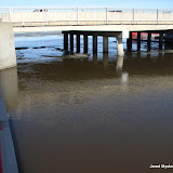
End Of The Flood
Confirmation this evening by Regina city workers monitoring Wascana Creek
the #SaskFlood has peaked at this location http://youtu.be/TUX-pu0Cj3E

the #SaskFlood has peaked at this location http://youtu.be/TUX-pu0Cj3E
Sunday, May 05, 2013
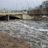
Flood Watch 2013-05-05 (Geo-Tagged)

Click the photo above to see the map and all 63 geo-tagged photos from around the Regina Wascana flood zone. Below are some of the most significant shots of the day. Due to the early opening of the flood gates, areas downstream are much higher now compared to the lake relative to 2011 flood levels.
Video will be processed overnight and another trip around the lake before sundown will give a good indication of how fast things are developing with temperatures now over 20C.


Flood Watch - Sunday, May 5, 2013 - 1pm
Water is starting to jump onto the path in some areas of Wascana Lake today.

I will make a full post when I get back, heading to the creek now to shoot footage. Reporting from the Saskatchewan Legislature ,
Jared Mysko

I will make a full post when I get back, heading to the creek now to shoot footage. Reporting from the Saskatchewan Legislature ,
Jared Mysko
Saturday, May 04, 2013
More Geo-Tagged Photos From Today / Park Flooding
The rising waters on Wascana Creek are starting to enter the park on the west side of Albert Street in Regina, Saskatchewan today.
Flood Watch 2013-05-04 (Geo-Tagged)

Click the photo to see the album and map.
16 photos with geographical location id
All content by Jared Mysko
Flood Watch 2013-05-04 (Geo-Tagged)
Click the photo to see the album and map.
16 photos with geographical location id
All content by Jared Mysko
Friday, May 03, 2013
INCREDIBLE TIDAL WAVE OF ICE ON THE SASKATCHEWAN
A rare sight to behold, a surge of rising water on the Saskatchewan River crushes through an ice jam in north east Saskatchewan on Wednesday.
Ice Surge - Saskatchewan Water Security Agency
Ice Surge - Saskatchewan Water Security Agency
Wascana Flooding Situation - May 2, 2013 #Regina #Saskatchewan
NEW Video from yesterday:
Playlist of all footage so far from around Wascana Lake as the flooding situation develops:
Playlist of all footage so far from around Wascana Lake as the flooding situation develops:
Flood Watch 2013-05-02 (Geo-Tagged)
Click the above photo to see the location map of 16 photos of the flood situation around Wascana Lake and Creek in Regina, Saskatchewan as of Thursday, May 2, 2013
Flood Watch 2013-04-29 (Geo-Tagged)
Click the above photo to see the location map of 5 photos of the flood situation around Wascana Lake and Creek in Regina, Saskatchewan as of Monday, April 29, 2013
Flood Watch 2013-04-28 (Geo-Tagged)

Click the above photo to see the location map of 11 photos of the flood situation around Wascana Lake and Creek in Regina, Saskatchewan as of Sunday, April 28, 2013
Flood Watch 2013-04-27 (Geo-Tagged)

Click the above photo to see the location map of 11 photos of the flood situation around Wascana Lake and Creek in Regina, Saskatchewan as of Saturday, April 27, 2013
Flood Watch 2013-04-26 (Geo-Tagged)

Click the above photo to see the location map of 6 photos of the flood situation around Wascana Lake and Creek in Regina, Saskatchewan as of Friday, April 26, 2013
Monday, April 29, 2013
First Severe Storm In Saskatchewan/Wascana Lake Rising
The first severe thunderstorm in Saskatchewan occurred this evening with a warning issued by Environment Canada at 6:06pm for areas of the extreme southern portions of the province, Bengough, Willow Bunch and St. Victor. It was only severe on radar for a short time and the warning was dropped at 6:53pm. Other non-severe thunderstorms crossed the southern areas of the province this afternoon and these systems will turn to snow tonight. Moosimin, Yorkton and Kamsack areas of eastern Saskatchewan are now under a snowfall warning for up to 20cm of snow by Tuesday.
"Wascana Jam"
After the longest, harshest winter on record, the snow is finally melting and Wascana Lake is rising! Starting April 26th, each day we are covering this story as it develops. Here is the playlist of a series of videos being taken around the flood zone in Regina:
"Wascana Jam"
After the longest, harshest winter on record, the snow is finally melting and Wascana Lake is rising! Starting April 26th, each day we are covering this story as it develops. Here is the playlist of a series of videos being taken around the flood zone in Regina:
Saturday, April 13, 2013
Is Spring Here Yet? The Birds Think So!
Since we have waited so long for spring to arrive, I decided to take some bread down to Wascana Lake and feed the birds. Only a few days ago it was rare to even see any birds around Regina but the last two days have proved they are back and populating the lake in a hurry! On Wednesday I estimated about a thousand birds on the lake and yesterday that figure easily jumped past a million. There was only one little area of birds the first day and Friday the entire lake was filled like I had never seen before. Feeding just a few birds got the entire flock to take flight in a spectacular display!
I shot a lot of video as it was such an amazing experience to stand there and watch. Look at the incredible difference two days make:
Here is Wednesday's footage:


Friday:


If you go, bring lots of bread and don't worry, if you run out they won't attack. haha
I shot a lot of video as it was such an amazing experience to stand there and watch. Look at the incredible difference two days make:
Here is Wednesday's footage:


Friday:


If you go, bring lots of bread and don't worry, if you run out they won't attack. haha
Sunday, March 24, 2013
March 24, 2013 - Record Snowfall In Regina - UPDATED with VIDEO
Video and photos from today as the sun finally came out for the first time in many days. According to news reports, we broke the record for snowfall in one winter season a week ago. Another 10 to 20 cm fell since to insure the highest total in recorded history for the city of Regina. Warm sunny weather next week will begin the next phase as the spring run off, melt and subsequent flooding will begin.
Video:


see more photos click here
Subscribe to:
Posts (Atom)