

Play by Play Commentary on Local and International Weather Events
Documentation and Relay Alerts of Severe Weather Events from Regina, Saskatchewan.
The Source Since 2002
Monday, June 27, 2016
NWT - Storms Way Up North Today [Risk Map]
Storms way up north today. North West Territories regions under an active severe thunderstorm watch.
"1:14 PM MDT Monday 27 June 2016
Severe thunderstorm watch in effect for:
Hay River Region including Enterprise
Conditions are favourable for the development of severe thunderstorms this afternoon and evening along the Mackenzie River and southern Great Slave Lake from Fort Simpson to Hay River.
Thunderstorms are beginning to develop over the region. The thunderstorms will strengthen this afternoon, with hail to the size of quarters and damaging winds in excess of 90 km/h possible.
Thunderstorms will weaken this evening."
Public Weather Alerts for Canada:
http://weather.gc.ca/warnings/index_e.html
Here is today's Risk Map:

Friday, June 24, 2016
"Several areas to watch this afternoon.." [1pm Updated Risk Map]
Several areas to watch this afternoon for the development of severe thunderstorms. Heavy rain, flash flooding, large hail and intense lightning are the main concerns today and into the overnight.
In the north, slow moving storm cells may trigger flash flooding and large hail throughout the afternoon and into the evening.
Further south, mainly in south western Manitoba, a strong cold front will trigger supercells late this afternoon and move east overnight. Extreme amounts of precipitation with large hail and possible microbursts could cause localized damaging wind gusts. Very intense lightning will also be of a concern, especially near game time in Winnipeg as the CFL season kicks off there tonight.
Here is the latest detailed risk map for today:


Friday, June 17, 2016
Daytime Clearing - Nighttime Derecho [Saturday's Risk Map]
With clear skies expected across the prairies on Saturday, daytime heating will to lead to severe weather developing overnight and into Sunday. Strong damaging winds and heavy rain with flash flooding are the main concerns. The situation may in fact become a "derecho" type event.
(A derecho (pronounced similar to "deh-REY-cho" in English, or pronounced phonetically as " ") is a widespread, long-lived wind storm. Derechos are associated with bands of rapidly moving showers or thunderstorms variously known as bow echoes, squall lines, or quasi-linear convective systems.) Source: http://www.spc.noaa.gov/misc/AbtDerechos/derechofacts.htm
Along the international border, storms are expected to be strongest and move east at a minimum of 80km/hr. It will move so fast that the storm system will start up in Montana Saturday night and end up in northern Ontario on Sunday morning. Since these powerful type of systems can cause widespread damage with gusts of between 100 and 120km/hr, areas near or around the main storm system will be affected. Heavy rains with supercell thunderstorms will precede the damaging wind event. Tornadoes and large hail are also possible ahead of the squall line.
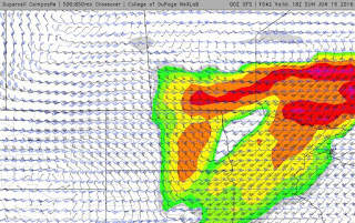
Here is the latest graphic from the GFS storm model showing midnight Saturday's Supercell Composite Index:
As you can see in this second snip, the strongest areas of strength move all the way into northern Ontario by noon Sunday, only 12 hours after the first graphic, seen above.
Our preliminary risk map, outlining the area of most concern for Saturday night:

(A derecho (pronounced similar to "deh-REY-cho" in English, or pronounced phonetically as " ") is a widespread, long-lived wind storm. Derechos are associated with bands of rapidly moving showers or thunderstorms variously known as bow echoes, squall lines, or quasi-linear convective systems.) Source: http://www.spc.noaa.gov/misc/AbtDerechos/derechofacts.htm
Along the international border, storms are expected to be strongest and move east at a minimum of 80km/hr. It will move so fast that the storm system will start up in Montana Saturday night and end up in northern Ontario on Sunday morning. Since these powerful type of systems can cause widespread damage with gusts of between 100 and 120km/hr, areas near or around the main storm system will be affected. Heavy rains with supercell thunderstorms will precede the damaging wind event. Tornadoes and large hail are also possible ahead of the squall line.
Here is the latest graphic from the GFS storm model showing midnight Saturday's Supercell Composite Index:

As you can see in this second snip, the strongest areas of strength move all the way into northern Ontario by noon Sunday, only 12 hours after the first graphic, seen above.

Our preliminary risk map, outlining the area of most concern for Saturday night:

Wednesday, June 15, 2016
Incredible Shelf and Lightning Photos and Video - June 14, 2016
Timelapse from 64x to 16x all footage shot between 9 and 10pm on June 14, 2016
Incredible Shelf Cloud with lightning over Wascana Lake and the Saskatchewan Legislature in Regina this evening just before 10pm
All footage by +Jared Mysko Storm & Wildlife Photographer Adventurer @jaredmysko


Incredible Shelf Cloud with lightning over Wascana Lake and the Saskatchewan Legislature in Regina this evening just before 10pm
All footage by +Jared Mysko Storm & Wildlife Photographer Adventurer @jaredmysko


Today's Risk Map
Storms from Montana may drift into south eastern Saskatchewan and Manitoba and become marginally severe later this evening. Heavy rains in north central Alberta and general thunderstorms in northern Manitoba.


Saturday, June 11, 2016
Today's Risk Map - "Extreme Instability"
Something to keep an eye on today... extreme instability along the international border should keep the risk of tornadoes about the Montana/North Dakota/Saskatchewan border intersection. The heavy rains are expected in south western Saskatchewan this morning and burn off with day time heating. Storms will fire up later this afternoon in Montana and remnants could drift into the southern most area of south east Saskatchewan. Risk of storms will be highest after 6pm for Estevan.


Thursday, June 09, 2016
Today's Risk Map: #skstorm #mbstorm
Moderate Risk for areas along the southern Manitoba/Saskatchewan border. Chance of a tornado, large hail, damaging winds and intense lightning. Storms are expected to initiate rapidly around 3pm in south east Saskatchewan and strengthen as they move northeast into southern Manitoba. Peak intensity of these storms will be between 3pm and 8pm.


Wednesday, June 08, 2016
Storms Ramping Up Today, Look Out For Tomorrow!
Widespread severe thunderstorms late this afternoon, strengthening into the evening and then running all night. Hot and humid air today will give rise to strong thunderstorms including supercells with golfball size hail and wind gusts up to 100km/hr. On Thursday morning, the remnants of today's storms will quickly emerge in south east Saskatchewan and move into southern Manitoba with near maximum force. This will be a dangerous situation. Areas from Yorkton to Winnipeg should prepare now for extremely severe weather tomorrow afternoon and into the evening.


Subscribe to:
Posts (Atom)