Monday, July 10, 2017

High Risk Verified - Monday Expected to Be A Big Day

A high risk for severe thunderstorms was issued early Sunday morning for western Alberta with a chance of tornadoes and extremely large hail.


 By 5pm one tornado was confirmed and reports of tennis ball sized hail were included in multiple tornado warnings throughout the evening, from Rocky Mountain House to Drumheller, Alberta.

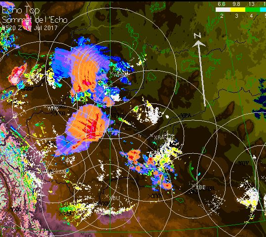
Storm continue to maintain maximum strength late overnight and by 11:30pm cells began to quickly pop up in western Saskatchewan. Here is an image grab of echo tops radar and lightning at that time:


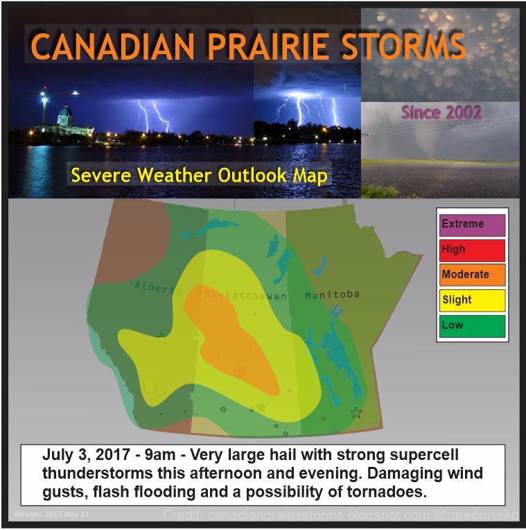
 A day 2 moderate risk was issues in the early afternoon and that is expected to be expanded by morning for most areas of southern Saskatchewan on Monday afternoon. Extremely large hail with damaging wind gusts and tornadoes. Link to PASPC Current Outlook


 Many storm chasers are committed to converge on the area, such as the world record holder for tornado intercepts Roger Hill and his Silver Lining tour company. Also world famous storm chaser, Reed Timmer tweeted this:
We will continue to monitor this situation closely and posts will be frequent on our Facebook page.

Thursday, July 06, 2017

Destructive Tornadic Storms - July 5, 2017

The day started off very early with morning convection just north of Regina which brought intense lightning and pea size hail to the area from 5:30am to 7am. I managed to snap a few photos and videos as it passed by.

This was as the sun rose at 5:30am looking north east from downtown Regina:


It actually began to gain strength at 6am when I started shooting this video from my deck:


After a couple hours and a report of pea size hail east of the city, it died out. Then we waited with great anticipation for what was to become the main event later in the afternoon. At 4:33pm clouds began to twirl and spin by, showing the incredible instability that was in the atmosphere mixing with extremely high CAPEs (Convective Available Potential Energy). This video was shot off my back deck (time-lapse 32x speed), facing south east:


Echo Tops radar began to show the progression of the birth of tornadic supercells at 5:50pm from Dauphin, Manitoba to Carlyle, Saskatchewan:


Within only a few minutes, what was only a few blips on radar suddenly became severe warned thunderstorms. Image from 6:20pm:


The first of many tornado warnings was issued near the radar site of Foxwarren, Manitoba:

"8:18 PM CDT Wednesday 05 July 2017
Tornado warning in effect for: Prairie View Mun. incl. Bird Tail Creek Res. R.M. of Yellowhead incl. Shoal Lake and Elphinstone Rossburn Mun. incl. Waywayseecappo Res.
.."


By 7:30pm SST (8:30 CDT or Manitoba Time) echo tops indicated a fully formed tornadic supercell covering the area along the southern Manitoba and Saskatchewan border:


By 8:24pm SST (9:24 CDT) there were 4 active tornado warnings in Manitoba and 1 in Saskatchewan. The one in Saskatchewan would prove to be the main producer on the extreme south west corner of the supercell. Greg Johnson tweeted out this photo at 8:57pm SST (9:57 CDT):


Later in the evening and the next morning reports rolled in with hail the size of baseballs and damage to a house near Alida, Saskatchewan:


Finally, Dan Lindsey and Atmospheric Scientist from NOAA/NESDIS tweeted out an incredible image from the newly launched GOES16 Satellite, dubbed as the future of weather observation and forecasting. This is the new high resolution animated satellite image of tornadic supercell over southern Manitoba and Saskatchewan:


Monday, July 03, 2017

Extreme Heat Wave - Moderate Risk

July 3, 2017 Severe Weather Outlook Map #ModerateRisk #skstorm #SlightRisk #abstorm #mbstorm Strong early morning thunderstorms in north-western Saskatchewan are expected to expand and intensify south-eastward this afternoon and evening. Very large hail up to 4cm in diameter with damaging wind gusts will be the main feature to watch. Flash flooding, very intense lightning as well as a chance of tornadoes will also be a concern to be prepared for. If tornadoes form, they may become strong with very organized right turning storm cells. Here is the outlook map and current lightning as of 9:30am:


Heat warnings continue in Alberta and are expected to expand into Saskatchewan later this week. High temperatures forecast for today:
Medicine Hat 33C
Lethbridge 30C
Swift Current 32C
Regina 32C
Saskatoon 30C
By the end of the week those temperatures will feel cool compared to what is forecast.
Saturday forecast highs:
Medicine Hat 38C
Lethbridge 36C
Swift Current 36C
Regina 34C
Saskatoon 34C