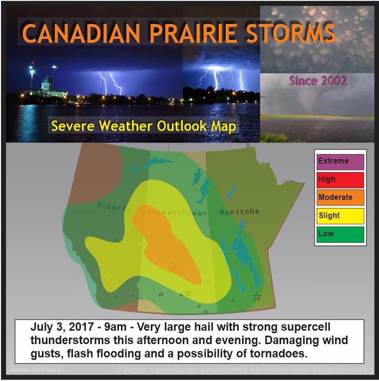
Monday, July 03, 2017

Extreme Heat Wave - Moderate Risk

July 3, 2017 Severe Weather Outlook Map #ModerateRisk #skstorm #SlightRisk #abstorm #mbstorm Strong early morning thunderstorms in north-western Saskatchewan are expected to expand and intensify south-eastward this afternoon and evening. Very large hail up to 4cm in diameter with damaging wind gusts will be the main feature to watch. Flash flooding, very intense lightning as well as a chance of tornadoes will also be a concern to be prepared for. If tornadoes form, they may become strong with very organized right turning storm cells. Here is the outlook map and current lightning as of 9:30am:


Heat warnings continue in Alberta and are expected to expand into Saskatchewan later this week. High temperatures forecast for today:
Medicine Hat 33C
Lethbridge 30C
Swift Current 32C
Regina 32C
Saskatoon 30C
By the end of the week those temperatures will feel cool compared to what is forecast.
Saturday forecast highs:
Medicine Hat 38C
Lethbridge 36C
Swift Current 36C
Regina 34C
Saskatoon 34C


Tuesday, June 20, 2017

Facebook Plugin Added

You can now see our Facebook Page without leaving the blog. This may be useful for reading tweets in the sidebar and keeping up with discussion on Facebook during busy storm days. This is just in the development stage at the moment but a new layout and dedicated page for this may be created in the near future. For now, bookmark this page and test it out. The current layout is most ideal for viewing on large screen (TV or computer monitor). Feedback is always encouraged and most appreciated. Please use the Facebook page for all comments and suggestions. Thank you.


Friday, June 09, 2017

Early Morning Storm Front with Pink Shelf and Roll Cloud


Early Morning Shelf Cloud by Jared Mysko on 500px.com
5:04 am, June 9, 2017 - A powerful nocturnal thunderstorm arrived in Regina, bringing a pink shelf and 3 sets of roll clouds. The forecast verified and I luckily woke up just in time to chase it by mountain bike only a few blocks from home. I quickly snapped a few photos in front of the Shoppers Drug Mart and then raced down to the shores of Wascana Lake. Quickly realizing time was running out, I manages one decent photo and headed back. A few more photos and an attempted timelapse did not work out as well since it got dark fast but I did see a couple of intense CG lightning strikes right downtown. After posting photos on Twitter, the Internet took over. I made a Twitter "Moment" to recap the excitement here:

Photo prints are now available on 500px:


Videos from YouTube:


Photos:


Wascana Lake

Second Wave


Friday, June 02, 2017

Tornado at Three Hills, Alberta - June 2, 2017 - Time Lapse


Social media exploded with activity just after 5pm Alberta time today as this tornado was spotted near Three Hills, north east of Calgary. Earlier in the day, a major hail storm hit Saskatoon and most of southern Manitoba was breaking day time high temps with a growing supercell size thunderstorm that is still sweeping across that province. Storm season is fully underway now and it is expected to be a busy one with already multi-day events becoming the norm. Next big system could hit Monday in BC/Alberta and Saskatchewan on Tuesday. Stay tuned for more updates and be sure to follow us on Facebook where posts will be most frequent.

https://www.facebook.com/CanadianPrairieStorms/

Earlier today in Saskatoon via Ryan Kayseas


Sunday, May 28, 2017

Saskatchewan/Manitoba Windy Today, Monsoon For Bangladesh... [GLOBAL WIND MAPS]

It is a fairly windy day today in Saskatchewan and Manitoba and some garden type thunder showers may affect isolated areas this afternoon but nothing special.

Looking at the global wind map, the rest of North America is fairly calm. The strongest winds on Earth right now are all surrounding the continent of Antarctica, with maximum sustained winds of 89km/hr. In the Bay of Bengal, a Tropical Cyclone is forming into a Monsoon with current maximum sustained winds of 64km/hr. Landfall is expected for Bangladesh and Myanmar this week. The calmest continents on Earth right now are Africa and South America. Here are some snaps of the current wind maps around the globe as of 2pm SST for comparison.

Wednesday, May 24, 2017

Inland Cyclone Taking Shape (World Animated Wind Map)

Check out this incredible image of the "Inland Cyclone" as it begins to take shape.


See the current map with animated motion here:
Earth Wind Map

Remember to bookmark our data links page as this link and more are saved there.
Data Links

Tuesday, May 23, 2017

Inland Cyclone Hits Wednesday

Looking at the latest GFS forecast model, an area of southern Alberta between Calgary and Medicine Hat will be the focus of a major wind storm on Wednesday. Peak sustained winds of 73 knots or 135km/hr are showing up as of 0z or 6pm local time. Tree and property damage begin to occur at 80km/hr which is the criteria to issue wind warnings by Environment Canada. This will go way above and beyond that so widespread power outages and major widespread damage will occur across most of the province. A special weather statement is already in place for the region and expect warnings to be issued very early so people can prepare. To put this into perspective, 135km/hr winds would make this a category 1 hurricane but since it is on land, it is considered an "Inland Cyclone".


In the graphic above, the purple area is 135km/hr, the red covering most of southern and central Alberta is 90 to 130km/hr. The yellow, which will affect nearly every area from Alberta to Manitoba is 55 to 90km/hr sustained winds. It is expected to last a strong two to three days and weaken by Friday. Keep in mind, this is just a model estimate and strengths and locations may shift. Wind gusts will be stronger, heavy rain and a drop in temperature is also expected. Check your local forecast and read all statements and warnings closely.

Thursday, April 27, 2017

Storm Season Gets Closer - May 6th?

Long term forecast models are showing a brief heat wave across Alberta and Saskatchewan, peaking May 6th with possible high temperatures of 26C. A cold front following off the mountains seems to suggest action within the supercell composite as well in west central Alberta. Certainly no guarantees on the timing, location, or intensity but something to note. Maybe just a glimmer of hope or maybe there will be some big storm action. By the looks of the map, the heat goes very far north into both Saskatchewan and Alberta. Remember, that is May 6th, a full 9 days out.


Image via http://weather.cod.edu/forecast/