

Play by Play Commentary on Local and International Weather Events
Documentation and Relay Alerts of Severe Weather Events from Regina, Saskatchewan.
The Source Since 2002
Saturday, June 20, 2015
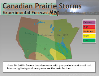
Storms Moving Into Manitoba Today
After a very active day yesterday, systems are pushing east into Manitoba. Today's storms are not expected to be tornadic or have very organized supercellularities thus, the slight risk is only for gusty winds, small hail, intense lighting and heavy rains. After today, if anything severe, the rest of next week is forecast to have general to marginal thunder showers and nothing very severe until closer to Canada Day. July 1st to 3rd is looking like the next big system at the height of storm season on the Canadian Prairies. Plan accordingly and as always, be prepared and stay safe!
Friday, June 19, 2015
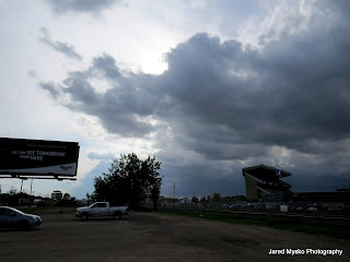
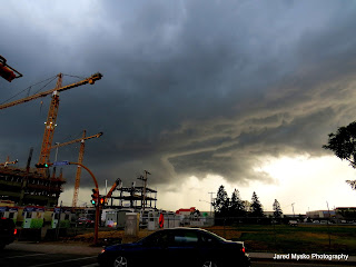
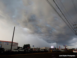
Storm Chasing Action via Mountain Bike!
Regina, Saskatchewan
June 19, 2015
5:50pm to 6:30pm
Began to see nice structure by the stadium construction site. At Dewdey and Lewvan Drive, I decided I had gone far enough as a rain and hail shaft began to appear! Initially, radar had indicated that it was moving slowly south east (15km/hr), making for an easy chase by bike. But suddenly, the line of cells began to wrap around and the south end rapidly flew across the city (after analysis at home, calculated it clocked up to 60km/hr and became tornado warned just 70km east of the city). Rode the storm home in 20 minutes via mountain bike! Some footage shot in action as i strapped the camera to my back and booked it towards safety! Now that's storm chasing! Pea size hail and a brief heavy downpour as I got home. Barely got wet.
Storm Chasing By Mountain Bike Today - Photos - 7pm Tornado Warning
Began to see nice structure by the stadium construction site. At Dewdey and Lewvan Drive, I decided I had gone far enough. Rode the storm home in 20 minutes via mountain bike! Now thats storm chasing! Pea size hail and downpour as I got home. Barely got wet.
[scroll down for warning]


 ...and now:
[scroll down for warning]


7:00 PM CST Friday 19 June 2015
Tornado warning in effect for:
Tornado warning in effect for:
- R.M. of Francis including Vibank Sedley and Odessa
- R.M. of Indian Head including Indian Head and Sintaluta
- R.M. of Montmartre including Assiniboine Res.
Updated or ended by 7:59 p.m. CST.
At 7:00 p.m. CST, Environment Canada meteorologists are tracking a severe thunderstorm that is possibly producing a tornado. Damaging winds, large hail and locally intense rainfall are also possible.
Weather radar indicates a potential tornado approximately 15 km south-southwest of Indian Head. This storm is travelling to the southeast at approximately 50 km/h. The storm will track southeastwards to the north of Highway 48.
Subscribe to:
Posts (Atom)