

Play by Play Commentary on Local and International Weather Events
Documentation and Relay Alerts of Severe Weather Events from Regina, Saskatchewan.
The Source Since 2002
Tuesday, June 07, 2016
Moderate Risk Today: Calgary Area [Today's Risk Map]
Moderate Risk today for areas along the dry line between Sundre and High River, Alberta. This carries a risk of an isolated tornado to go along with supercell thunderstorms reaching strengths of 110km/hr wind gusts and hail up to 4cm or an inch and half.
Take all Environment Canada warnings and watches seriously today and stay extra weather aware if you are in areas along the foothills of Alberta today.

Monday, June 06, 2016
Busy Week Ahead! Lets Start In Alberta...
High based supercell thunderstorms in west central Alberta today with risk of golf ball size hail and wind gusts up to 100km/hr. #abstorms
This system is expected to gain strength as it comes off the foothills and cross the prairies this week. The risk moves south east tomorrow into southern Alberta and western Saskatchewan. Long term forecast models have shifted Wednesday and Thursday back and forth between Manitoba and southern Saskatchewan for an enhanced risk of extremely severe thunderstorms. We continue to monitor the situation closely but for sure something big is brewing for later in the week.


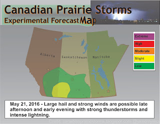
Saturday, May 21, 2016
Updated Risk Map 6pm SST #skstorm
Rapid expansion northwards of severe thunderstorms in Montana at the moment. Updated risk map as of 6pm SST laying out a slight risk for mainly south west Saskatchewan. Latest storm forecast models suggest storms will track north towards the Kindersley/Rosetown region this evening and dissipate in strength.


First Big Storms Saturday In Saskatchewan #skstorm [Risk Map]
Strong to damaging winds will be the main issue over most of southern Saskatchewan on Saturday. Thunderstorms may become severe with intense lightning, strong wind gusts and brief downpours of rain. These storms are expected to emerge late in the afternoon in extreme south west Saskatchewan and slowly track east into the evening. A very marginal tornado risk does exist as well as a chance of hail reaching severe levels very briefly within the strongest cells. Next update, around 2pm.
Remember to follow Environment Canada watches and warnings for the latest and follow "Storm Tweets" as they come in via our blog: http://canadianprairiestorms.blogspot.ca/p/weather-data-links.html
Tips: Be prepared and have a safety plan in place. Have your weather radio, cell phone, cameras, candles and flash lights charge and at the ready.
Stay safe and enjoy the weather!

Thursday, May 19, 2016
Today's Forecast Show #skstorm Saturday?
Here is the archive of our Severe Weather Forecast Show, originally aired via Facebook at 9:30pm Thursday, May 19, 2016
Severe Weather Forecast Show - May 18, 2016
Here is our second Severe Weather Forecast Show that was broadcast yesterday evening via Facebook. Looking at the coming storm situation this weekend and possibility of big storms in Saskatchewan on Saturday. The next show is scheduled for 9:30pm SST tonight for another update on what the forecast models are saying.
Be sure to like and bookmark us:
https://www.facebook.com/CanadianPrairieStorms/
Be sure to like and bookmark us:
https://www.facebook.com/CanadianPrairieStorms/
Tuesday, May 17, 2016
Severe Weather Forecast Show [Interactive Presentation]
Here is the recorded video of our first live forecast show:
Monday, May 09, 2016
Extreme up-close video of tornado near Wray, CO! (May 7, 2016)
Video courtesy of @reedtimmertvn @accuweather
Filmed on May 7th, 2106 near Wray. Colorado
This looks to be tornado of the year so far but its still very early in the season.
Another perspective of this tornado can be seen via 360° video:
https://www.youtube.com/watch?v=TCXp9Y5uPn4
Subscribe to:
Posts (Atom)