Today's Song via YouTube Music
Canadian Prairie Storms Pages
Sunday, August 20, 2023
Kelowna Fires / Hurricane Hillary / Tropical Storm Trudeau / Supercell Wednesday
Thursday, August 17, 2023
The Next Big System
Thursday, August 17th, 2023
Today's Thunderstorm Outlook from ECCC, showing a large risk area from the foothills through Edmonton to Lloydminster, Alberta. |
Extreme heat is expected to push east into Saskatchewan and Manitoba on Friday. Depending on the timing, the short term forecast showing Regina hitting 97F/35C at 2pm while the high resolution mid-term forecast saying Brandon, Manitoba will get the big time heat wave.
Either way, there is a big system coming over the mountains which will affect everyone on the Canadian Prairies over the next few days. Expect a lot of wind, heat waves and storms to follow through the weekend until Sunday as it exits Manitoba. Good thing is, the rain should help knock down a few fires however with record ocean temperatures this summer, we should keep our A/C's up a few more weeks. Might stay hot with supercell thunderstorms much later this summer.
Friday, August 11, 2023
Storm Front Timelapse Videos from August 10th, 2023
Thursday, August 10, 2023
Storm Day Thursday, August 10th, 2023
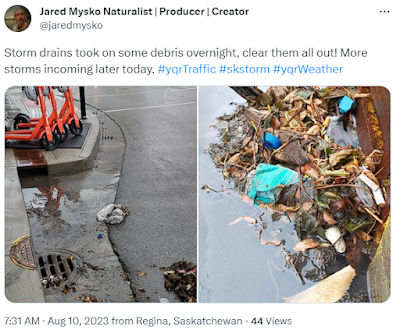
 Storm drains had to be cleared out this morning after heavy rain and thunder overnight in Regina.
Smoke clears out at 4pm in ReginaForest Fires (FireSmoke.ca)
Wednesday, August 09, 2023
Moderate Risk Day 2 Thursday, August 9th, 2023
Moderate Risk Day 2 Thursday, August 9th, 2023
Tuesday, August 01, 2023
New Playlist: Old Music New Videos
Check out our new playlist on YouTube, all the new videos with old music will be showing up here:
Sunday, July 23, 2023
23/7/23 Tornado Risk Today / Maximum Heat Monday
Saturday, July 15, 2023
Update #3 Its Montana Monday/Mid Term Models
Monday is coming in hot for Montana. That is a storm that will need several cameras on it. #mtwx This composite radar image (NAM Nest) is for 8pm as it enters North Dakota. Big storms coming across the northern plains this week!
Wednesday, July 12, 2023
UPDATE #2 Next Big Storm System: July 18th and 19th, 2023
Checking the GFS forecast model, today's 12z update, the supercell composite continues to show an area of southern Saskatchewan, southern Manitoba, Montana and the Dakotas in the mix for supercell action from July 18th to July 19th for Canadian provinces, and continuing further south into the states July 20th.
Sunday, July 09, 2023
Smoke Enhibiting Thunderstorm Convection/Clearing Up This Evening
Comparing Models to Actuals / Major Manitoba Wind Storms TODAY
Saturday, July 08, 2023
Sunday's Outlook, Potential For Tornadoes
Thursday, July 06, 2023
Long Term Outlook GFS Goes Crazy July 18th,19th Supercell Composite
Sunday, July 02, 2023
Here comes the WIND! There goes the BIGGEST storm system of the YEAR 2023
Wind gust danger early this evening as the strongest storm system of the year is beginning to rear its ugly head in southern Manitoba. This system produced a violent, public and damaging tornado event in Alberta in the afternoon and a top secret microburst or tornado north of Regina on Saturday evening. Eccccccccccc says its a high risk in southeastern areas of Manitoba. Echo tops show a discrete supercell that had popped up a little further west than expected. Again, those downstream of tornadic supercells are in grave danger. Take extreme precautions, watch the weather and stay safe! (We will process the secret footage tomorrow and post all the incredible highlights of this season in the coming days, boring weather ahead for at least the next two weeks)
YouTube footage:
Violent Tornado Hits Homes Near Didsbury, Alberta
JayJack Storm Trax
Canada Day Convection to Supercell Microburst with Lightning
Saskatchewan Storms and Wildlife WondersSaturday, June 25, 2022
Tornado/Gustnado/Supercell/Shelf Epic Day: June 23rd, 2022 Comprehensive Summary
June 23rd, 2022 Comprehensive Summary of this Spectacular Epic Tornado Warning Fest, Hail Shaft Frenzy, Gustnado Apocalypse with Mammoth Sized Popcorn Clouds followed by the Orange Peel Mega Shelf Cloud and a Vigorous Lightning Engine Supercell that had no quit!
Tuesday, May 24, 2022
[Timeline of Events] Deadly Severe Weather Outbreak May 17 to 21 Saskatchewan/Michigan/Ontario/Quebec 2022
A probable tornado touched down on this farm near Caronport, Tuesday night around 7 p.m. #SKstorm pic.twitter.com/yB52i0rlgV
— CTV Morning Live Regina (@CTVReginaLive) May 18, 2022
To calculate the speed of the wind here all you have to do is know the distance between power poles and the speed of the debris that covers that distance. IF PowerPoleDistance=100m AND Debris speed is 3 seconds THEN it takes 30 seconds to go 1km WHICH = 120km/hr .. That is the speed of the outer bands of wind. The inner core of the tornado is obviously much higher, this looks like an EF3 which would correspond with similar events in Michigan from the same system. Environment Canada gave it a preliminary rating of EF0 because there were no reports of damage (unless SGI was to share information of course). The Western Ontario University Northern Tornado Project report can be viewed here: https://uwo.ca/ntp/blog/2022/landspout_tornado_near_caron_sk.html
As it super cooled off, another brief filming session with Kestrel temperature close monitoring as we saw it drop from 15C as the first sunshine came out after the rain, to 9C in about an hour!
May 18th
Vehicles impaled by debris here in Gaylord MI @SevereStudios pic.twitter.com/PaW2g6MeBs
— Jordan Hall (@JordanHallWX) May 21, 2022
The next morning started off with what was reported as hurricane force winds near London, Ontario.
Almost hurricane force winds on this line near Drumbo! @weathernetwork #ONStorm pic.twitter.com/BUKPOpL2l3
— Mark Robinson (@StormhunterTWN) May 21, 2022
This shockingly powerful storm ended up ripping across 1000km of the most populated areas of Ontario and Quebec including Toronto (121km/hr), Peterborough (130km/hr), Ottawa, Montreal and Quebec City. At least 5 were killed, unknown at this time the damage or total injuries. Historic Derecho for sure.
You can see the sheet of dirt and the car being pushed in the #ONStorm #ontstorm #ottnews @weathernetwork pic.twitter.com/Py6iJyxKEt
— Adam Safaoui (@adam_safaoui) May 21, 2022
Incredibly fitting, on May 22nd this is how it ended:
It's still chugging along pic.twitter.com/g30FnYgVbx
— Mike (@205mph) May 23, 2022
Tuesday, March 29, 2022
Waiting for Winter to End... videos of how it went Winter of 21/22 in Regina, Saskatchewan
Sunday, September 05, 2021
Videos from YouTube of the August 31st Damaging Hailfest and Weak Tornadoes
EDIT: Many videos have been taken down by YouTube, text remains but some of these are old broken links.
I have gone through YouTube and made a list of all the videos with significant footage of the historic August 31, 2021 Storm the hit the city of Regina. This was the closest we have come yet to capturing the return of "Regina Cyclone 2.0" Please excuse the video thumbnails, for they are hilarious but quite fake. The footage inside the videos is real, I have reviewed it all. Each of these video shows a different angle of this epic storm.
Apocalypse of Stones in Canada! 🚨 Hailstorm struck Regina, Saskatchewan832,505 views
This video shows a funnel with dust coming up of the ground which usually is enough to confirm an EF0 tornado. Tornado starts at 1:12 in the video. Travel With Costy's YouTube Channel:
SCARY THUNDERSTORM WIT HAIL STORM IN Regina, Saskatchewan. CANADA
https://youtu.be/ga9MAwrGha8
431 views
Wednesday, September 01, 2021
Saturday, June 26, 2021
Northwest Flow Brings a Microburst - Heatwave Incoming/Storms To Follow July 2nd
Thursday, June 10, 2021
Early morning Storm Discussion : Tornadoes Today!
Tuesday, January 19, 2021
2021 Storms Video Playlist / Hurricane Force Blizzard Hits Regina - January 13-14, 2021
Here is a playlist of videos from our YouTube channel from the Hurricane Force Blizzard that hit Regina, Saskatchewan on January 13 with aftermath video from the 14th, 2021.
"Heavy rain, freezing rain and well above normal temperatures began an historic day for the city of Regina, Saskatchewan. Wind speeds over 140km/hr were recorded just south of the city. Sustained winds over 94km/hr lasted about 3 hours 11pm to 2am. Widespread damage is being reported and cleanup is now underway. I went out for a couple walks during the storm and caught a few snow-nadoes and a lot of wild and scary winds!"
Saturday, August 01, 2020
Monday, July 20, 2020
Timelapse of Developing Storm Cells - July 20, 2020
Monday, July 22, 2019
Tornadic Supercell Lightning Machine
Friday, July 12, 2019
Tornado east of Rockglen
Footage by William Mysko
July 12, 2019
4:03pm near Rockglen
Pages
- Home
- Weather Data Links
- Social Media
- LIVE Storm Chase Feeds
- Tornado Fatalities in Saskatchewan 1898 to 1979
- June 1st, 1986 Three Tornadoes Strike Saskatoon's North End
- Education and History
- Storm Chasing/Meteorology/Weather Sites
- Risk Map Archives
- 2012 YEAR OF TORNADOES IN SASKATCHEWAN (video playlist)
- 2004 Photos
- Photos 2003
- Photos 2002
- Terms of Service / Privacy Policy


