Saturday and Sunday looks like it will be a moderate to high risk for severe weather in south east Saskatchewan and southern Manitoba. Baseball size hail with long lived supercells, significant tornadoes, dangerous lightning and damaging winds. Begin your tornado precautions NOW if in these areas, Yorkton south through Regina into Montana, east to the Red River Valley and all of south west Manitoba. Make your plans now and stay safe, monitor weather alerts closely and with full attention, charge weather radios, cell phones, and stock candles and food.
A detailed map will be outlined later tonight as models come in line with the forecast.
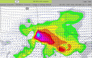
Here is the Saturday 6pm NAM Supercell Composite:

Sunday's GFS shows the Supercell Composite Index with soundings at 69.1 (translating to a PDS Tornado, "Particularly Dangerous Situation) just south of the Saskatchewan/Manitoba/North Dakota border intersection: