A heavy rain and intense lightning storm hit the city of Saskatoon a few hours ago and is slowly moving towards Regina at this time. If it hold together it may just catch the north end, spread out or nothing at all. Currently this small but powerful cell looks like a mini gust front with high tops, suggesting it will keep its strength by sundown near Regina where it should quickly dissipate.
Here is a look at the echo tops screen grab:
And today's outlook map:
Today's Song via YouTube Music
Canadian Prairie Storms Pages
Tuesday, July 23, 2013
Monday, July 22, 2013
Temporary Site Crash / Front Page News / Today's Risk Map
Today our little blog Canadian Prairie Storms made it to the front page of the Leader Post and soon after became unavailable until late this afternoon as restoration methods had to be implemented. As a result a new page was created on Facebook as a backup, this page will be maintained as time permits but feel free to give it a like and fill it with comments and reports.
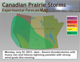
In today's weather news, Calgary has been issued a severe thunderstorm warning and tornado watch with many areas along the southern Alberta foothills in the risk zone. This activity is expected to continue all week until storms move into Saskatchewan next Sunday according to long term models. We will update as storms develop and models change. Here is today's outlook map:
Sunday, July 21, 2013
Subscribe to:
Posts (Atom)
Pages
- Home
- Weather Data Links
- Social Media
- LIVE Storm Chase Feeds
- Tornado Fatalities in Saskatchewan 1898 to 1979
- June 1st, 1986 Three Tornadoes Strike Saskatoon's North End
- Education and History
- Storm Chasing/Meteorology/Weather Sites
- Risk Map Archives
- 2012 YEAR OF TORNADOES IN SASKATCHEWAN (video playlist)
- 2004 Photos
- Photos 2003
- Photos 2002
- Terms of Service / Privacy Policy


