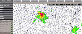
Extreme Southern Saskatchewan, including Assiniboine, Weyburn and Estevan Regions and All of Eastern Montana!
PLEASE BE PREPARED FOR STORMS ON WEDNESDAY
Severe weather models are pointing to a major system exploding with tornadic supercells over western Montana Wednesday afternoon and moving into extreme southern Saskatchewan into the evening. These damaging storms will move into southern Manitoba and south eastern Saskatchewan on Thursday, making this a 2 day severe weather event. If in these areas, make plans now for strong storms and possible tornadoes, power outages, flash flooding, large hail and damaging winds.
Here are some of the images of the latest forecast models, GFS and NAM, both seeming to suggest a lot of mixing with tons of wind shear, maximum ehi index and supercell composites, rain/precip just to the north. City of Regina could see flash flooding overnight with power outages all night Wednesday into Thursday.
 |
| GFS wind 850 9pm |
More updates as they come in...


No comments:
Post a Comment