PSPC (Prairie Storm Prediction Centre) for the 2pm update states, "
...THERE IS A MDT RISK OF SEVERE TSTMS OVER EAST CENTRAL SASKATCHEWAN AND WEST CENTRAL MB LATER TODAY INTO THIS EVENING. SLGT RISK OF SEVRE TSTMS OVER SERN SK/SWRN MB AS WELL AS WEST CENTRAL SK INTO EAST CENTRAL AB."
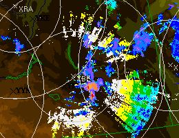
Our map shows this area with a high risk included for later on in the evening near sunset. A lone supercell came down the number 1 highway early this morning and seems to have parked itself over the city of Regina. Severe thunderstorm watches have been issued for all of central east and west Saskatchewan and central Alberta. These should be extended south and east as the day progresses and this cell begins to organize itself. Please pay very close attention to watches and warnings in your area today and this evening. Updates to this blog will be limited to the #skstorm column on the right hand side of this page.
 |
| Echo Tops Radar 1:20pm |
 |
| Echo Tops Radar 1:50pm |


