The footage of this tornado is amazing, lucky no one was killed but ABC news reports 9 injured as this tornado destroyed an oil camp in North Dakota May 26, 2014
Language and stupidity warning!

Play by Play Commentary on Local and International Weather Events
Documentation and Relay Alerts of Severe Weather Events from Regina, Saskatchewan.
The Source Since 2002
Tuesday, May 27, 2014
Dangerous Situation! #WednesdayNight
Extreme Southern Saskatchewan, including Assiniboine, Weyburn and Estevan Regions and All of Eastern Montana!
Stay safe, stay tuned and be prepared!
PLEASE BE PREPARED FOR STORMS ON WEDNESDAY
Severe weather models are pointing to a major system exploding with tornadic supercells over western Montana Wednesday afternoon and moving into extreme southern Saskatchewan into the evening. These damaging storms will move into southern Manitoba and south eastern Saskatchewan on Thursday, making this a 2 day severe weather event. If in these areas, make plans now for strong storms and possible tornadoes, power outages, flash flooding, large hail and damaging winds.
Here are some of the images of the latest forecast models, GFS and NAM, both seeming to suggest a lot of mixing with tons of wind shear, maximum ehi index and supercell composites, rain/precip just to the north. City of Regina could see flash flooding overnight with power outages all night Wednesday into Thursday.
 |
| GFS wind 850 9pm |
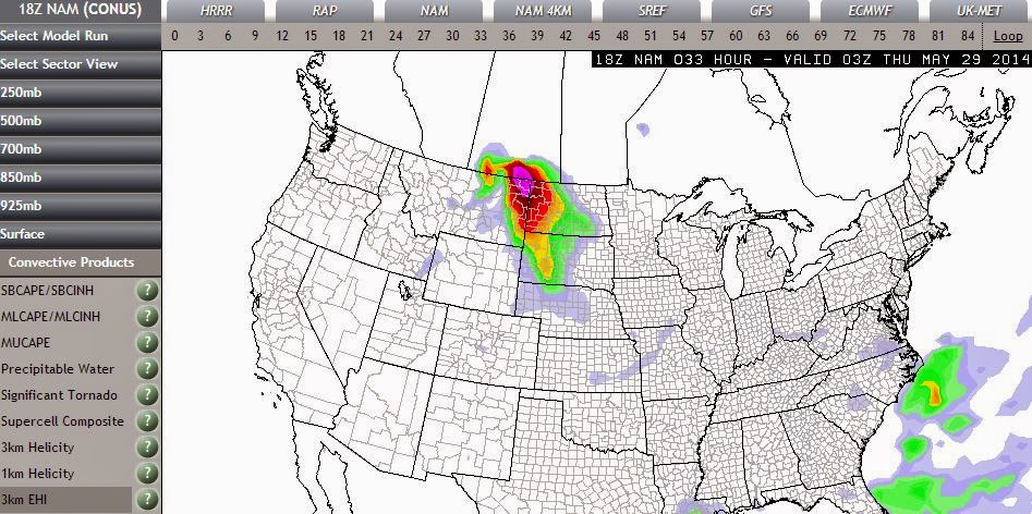 |
| NAM ehi index 9pm |
 |
| GFS precip 9pm |
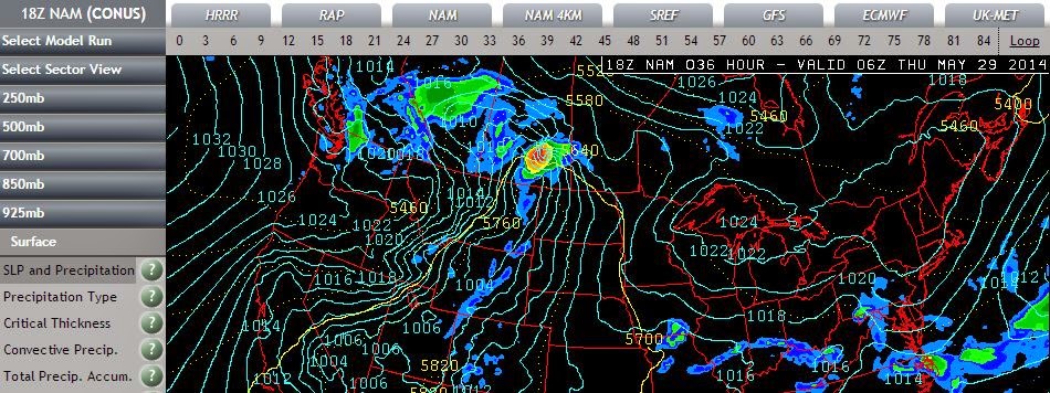 |
| NAM precip midnight |
 |
| GFS supercell 9pm |
 |
| NAM supercell 9pm |
Stay safe, stay tuned and be prepared!
More updates as they come in...
Monday, April 28, 2014
Storm Season Has Started In The States
A massive storm system has unleashed terrible fury in the latest start ever to tornado season in the states. Four days of severe weather had been forecast to hit southern tornado alley states starting on Saturday but after a blue sky bust that day, storms began to explode first thing Sunday morning and continue to pound many states into Monday evening with no slow down in sight. Moderate Risk was raised to High Risk early Sunday with 32 tornadoes reported on the Storm Prediction Center page. One was said to have been a multi-vortex with a destructive path of 80 or more miles long in Alabama with many injured and some killed.

NASA Satellite Images:
...and from today:
At the latest count as of 8:21pm SST, the tornado count for today stands at 33 with another Moderate Risk issued for tomorrow for states just east of today's storms. Follow twitter feeds on the right of this page or check our live chaser links below for the latest.
Stay Safe!!!!
Image grab from the animated wind map: (Apr27,2014-345pm) :
NASA Satellite Images:
Picture: Earlier large #tornado captured on the ground in SE Kansas via (@kmbc) http://t.co/w3bWMabu2g pic.twitter.com/K6uAGpF0xF
— Johnny Kelly (@stormchaser4850) April 27, 2014
...and from today:
@WTVAWeather @WCBIWEATHER @RennyV incredible pano shot of storm just over Crawford, MS. #mswx pic.twitter.com/njpGB64jC9
— Hayden Nix (@HaydenNix) April 28, 2014
Watching Brett Adair's live stream of #Lousville damaging tornado @TVNweather pic.twitter.com/rWKD50HHWY
— James Ridgway (@JamesRidgway) April 28, 2014
At the latest count as of 8:21pm SST, the tornado count for today stands at 33 with another Moderate Risk issued for tomorrow for states just east of today's storms. Follow twitter feeds on the right of this page or check our live chaser links below for the latest.
Stay Safe!!!!
Subscribe to:
Posts (Atom)