
Play by Play Commentary on Local and International Weather Events
Documentation and Relay Alerts of Severe Weather Events from Regina, Saskatchewan.
The Source Since 2002
Thursday, June 30, 2011
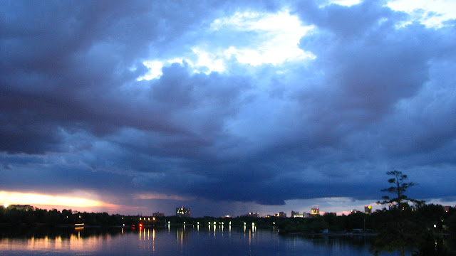
Storm Chasing In Manitoba Today - Sweet Lightning Shot Over Moosimin

of boiling soup of weather in south east Saskatchewan and waited all
day for the cap to break. After waiting in Grenfell for most of the
afternoon we moved on to Broadview and sat there for the evening.
Finally at 11:30pm the show got us going. Lightning intensified slowly
at first but soon the power began to flicker off at the Hotel lounge
where we waited. Shelf clouds were visible as we got on the highway as
sudden wind gusts made it clear that we had to move east. We found a
clearing and pulled over and took some video and photos of the storm
that was actually chasing us down. We did this a few times until
finding a rest stop on the Manitoba side of the border. The storm on
radar was most intense when it crossed the highway over Moosimin and
since it was moving at 70 km/hr north east, it was time to abandon the
chase and rest up for the next day.
Today, the forecast says large hail is the main threat if the cap
breaks, hopefully earlier today maybe around 6pm(CST) 5pm(SST). There
is a small probability of one or two tornadoes. Hope I've got the
times right but so far its been a very fun adventure. Met a lady that
showed me photos of turtles in the area which she promised to send me.
Much more stories to tell and videos will be posted later. We are
targeting south of Winnipeg somewhere close to the Manitoba/MN/ND
borders.
Tuesday, June 28, 2011
Storm Chasers Convergence - Something Brewing...
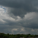
It was an almost ominously giddy get together for some of us, the first time meeting up with fellow weather enthusiasts this evening at Regina's Brewster's restaurant. Under clear skies and hot humid air moving in, about 15 or so members of Canadian Prairie Storm Chasers exchanged stories and forecast predictions while severe thunderstorms began to creep across the international border. Warnings are still up for south western Saskatchewan and since night fall a massive cell has continued to grow towards us. With a forecast high of 32C in Regina tomorrow, plans are for many of us to meet up early tomorrow and exchange thoughts before going out to chase down some tornadoes in southern Saskatchewan. The set up seems all too perfect for an outbreak of significant storms in the area, possibly further east and into Manitoba. Truly high time in the season for tornadic thunderstorms to occur which mainly runs on the Canadian Prairies from June to August. The peak of the season being the first two weeks in July. It is exciting and a bit scary to think what the next couple of days may hold. Safety and relaying relevant information will be our top priority as storm spotters and emergency relay operators.
Forecast - 6am June 28, 2011
I really doubt there will be any significant thunderstorms or tornado-fests over the next 3 days but some storm chasers sure are trying to make a big deal out of this. There is no deep low, no steep gradient, very little wind shear, only hot temperatures and extreme humidity. Of course, considering that I am always wrong, watch the forecast magically change. Current conditions never lie though. Its all clear on the prairies for as far as the eye can see. -Jared @ 6am June 28, 2011
UPDATE: Okay, I lied. According to this wind shear map, we are on the extreme side of shear. I should study a bit more about how they calculate shear, back to school for me.

UPDATE #2
"Vertical wind shear is the second critical factor in the determination of thunderstorm type and potential storm severity. Vertical shear, or the change of winds with height, interacts dynamically with thunderstorms to either enhance or diminish vertical draft strengths."
Source: University of Illinios
Saturday, June 25, 2011

Friday, June 24, 2011


Monday, June 20, 2011
Dark Skies Over The City - See More At http://www.canadianprairiestorms.blogspot.com


one produced only some light sun showers but darkened the skies over
downtown much of the afternoon as a small storm cell slowly creeped
its way west. Radar indicates that it is going in the opposite
direction of stronger storms in Alberta. It actually looks like it
will collide with another larger cell south of Moose Jaw and turn back
this way later tonight.
Sunday, June 19, 2011
Thunderstorm Over Wascana Lake - Regina, SK - June 19, 2011


city. Just some dark clouds and light rain. There was some nice
updraft above the Saskatchewan Legislature that only lasted a few
minutes. The first photo in this series was taken through the lense of
my sunglasses for a neat effect.
Saturday, June 18, 2011
Regina Thunderstorm - June 18, 2011
UPDATE:

Many tree branches were knocked down after a heavy rain storm that
brought flash flooding and high winds to the city of Regina,
Saskatchewan.
heavy rainfall and today it rose even more after this little
thundershower. Pea size hail landed at our house to motivate me to
ride into the park for a photo session and I was glad that I did.
Capturing some good thunder rumbles and cloud formations. One large
tree branch was down in the park but that might have happened earlier
as the winds were not much of a factor this afternoon. Gusts were much
stronger yesterday after approximately 7 cm of rain fell on the city
and most of southern Saskatchewan. Flooding is now becoming an issue
once again as areas in south eastern Saskatchewan got soaked over
already drenched farm land. I included a snapshot of me and my 'storm
chasing vehicle' in front of the Wascana Lake and Saskatchewan
Legislature.


Many tree branches were knocked down after a heavy rain storm that
brought flash flooding and high winds to the city of Regina,
Saskatchewan.


heavy rainfall and today it rose even more after this little
thundershower. Pea size hail landed at our house to motivate me to
ride into the park for a photo session and I was glad that I did.
Capturing some good thunder rumbles and cloud formations. One large
tree branch was down in the park but that might have happened earlier
as the winds were not much of a factor this afternoon. Gusts were much
stronger yesterday after approximately 7 cm of rain fell on the city
and most of southern Saskatchewan. Flooding is now becoming an issue
once again as areas in south eastern Saskatchewan got soaked over
already drenched farm land. I included a snapshot of me and my 'storm
chasing vehicle' in front of the Wascana Lake and Saskatchewan
Legislature.
Note: These are all raw, unedited photographs. Please do not steal! I
don't often enhance photos unless they really need it.
All content by Jared Mysko - Regina's Cyclone Psyco Storm Cyclist
:)
Wednesday, June 15, 2011
Three Tornadoes Today!!!
Busy day on the Canadian Prairies today, weather wise.
First, incredible photos of this violent looking tornado that the local media like to call funnel clouds. Judge for yourself:

Saskatoon Star Phoenix
Funnel cloud spotted near Birch Hills
News Talk 650 Radio
Funnel cloud spotted in Birch Hills | News Talk 650 CKOM
Other reports of funnel clouds in south eastern Saskatchewan. One north of Wapella, and another near Quill Lakes that didn't touch the ground.
Then, a tornado was captured in Alberta near Medicine Hat.

"Environment Canada has confirmed a small funnel cloud touched down around 50 KM east of Medicine Hat Tuesday afternoon near Walsh. Meteorologists say the weather system was so small it didn't even hit their radar, but warn weather for Wednesday looks much more daunting.
Significant weather Meteorologist Brian Proctor says south eastern Alberta could see several small funnel clouds develop as strong storm cells pass through the region."
via CHAT Medicine Hat
Finally, to round out the day. The city of Regina was treated to a show at sundown as a mini thunderstorm cell came into the city as I got a chance to photograph it and get totally soaked in the downpour that followed. Video will be up tomorrow and you won't want to miss it. I captured a nice bolt of lighting in front of a wall cloud as it cruised over the downtown skyline.
Much more will be uploaded tomorrow. Click here for today's album.
VIDEO!
First, incredible photos of this violent looking tornado that the local media like to call funnel clouds. Judge for yourself:
Saskatoon Star Phoenix
Funnel cloud spotted near Birch Hills
News Talk 650 Radio
Funnel cloud spotted in Birch Hills | News Talk 650 CKOM
Other reports of funnel clouds in south eastern Saskatchewan. One north of Wapella, and another near Quill Lakes that didn't touch the ground.
Then, a tornado was captured in Alberta near Medicine Hat.
"Environment Canada has confirmed a small funnel cloud touched down around 50 KM east of Medicine Hat Tuesday afternoon near Walsh. Meteorologists say the weather system was so small it didn't even hit their radar, but warn weather for Wednesday looks much more daunting.
Significant weather Meteorologist Brian Proctor says south eastern Alberta could see several small funnel clouds develop as strong storm cells pass through the region."
via CHAT Medicine Hat
Finally, to round out the day. The city of Regina was treated to a show at sundown as a mini thunderstorm cell came into the city as I got a chance to photograph it and get totally soaked in the downpour that followed. Video will be up tomorrow and you won't want to miss it. I captured a nice bolt of lighting in front of a wall cloud as it cruised over the downtown skyline.
Much more will be uploaded tomorrow. Click here for today's album.
VIDEO!
Tuesday, June 14, 2011

Monday, June 13, 2011
UPDATE: Flash Flood/Thunderstorm over Regina Today - June 13, 2011
Click photo for slide show
Doing some practice shooting with the camera and tripod today.
Here is the video:
Didn't expect much today but I wanted to test out the equipment. What started out as not much more than some pop up thunder-heads turned into a surprise flash flooding and mostly soaking system. It was brief but fun!
Doing some practice shooting with the camera and tripod today.
Here is the video:
Didn't expect much today but I wanted to test out the equipment. What started out as not much more than some pop up thunder-heads turned into a surprise flash flooding and mostly soaking system. It was brief but fun!
Saturday, June 11, 2011

Subscribe to:
Posts (Atom)